
What Is Indian Drainage System?
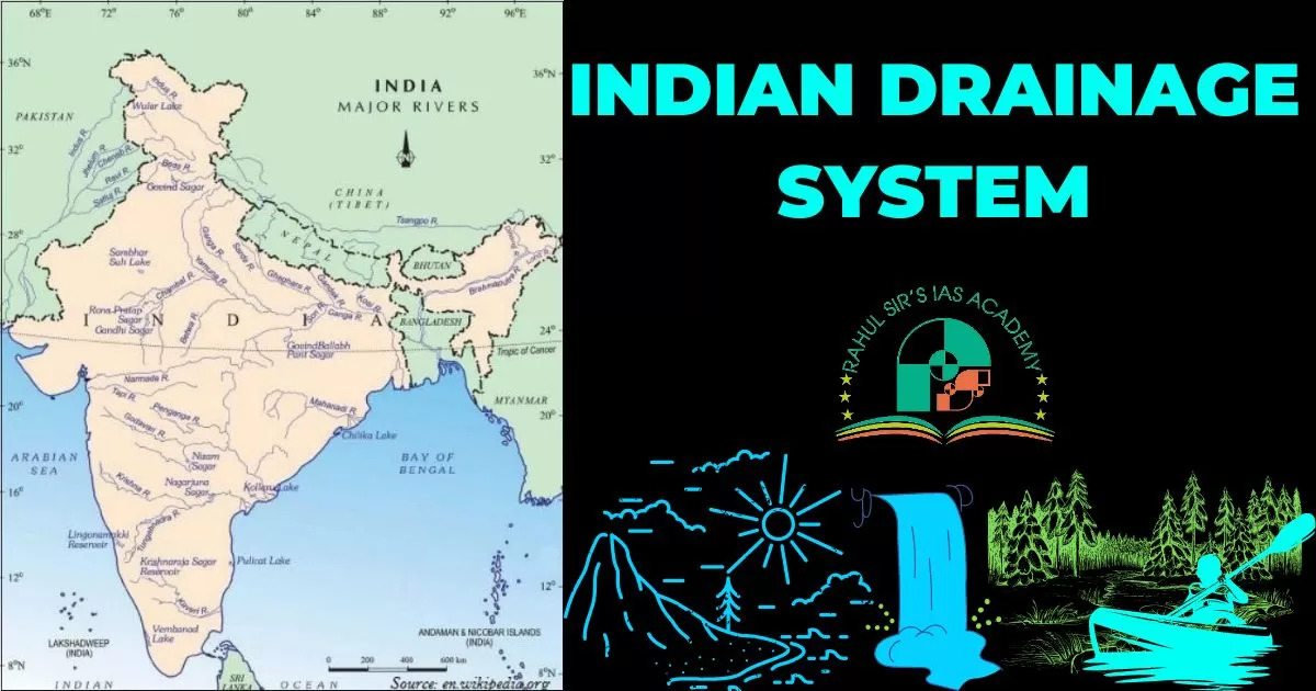
The Indian drainage system can be defined as a network of channels through which the river water flows in a well defined manner in India. The flow of water through well-defined channels is known as ‘drainage’ and the network of such channels is called a ‘drainage system’. India receives an annual average rainfall of 118 cm which provides 3645480 million cubic meter of water. Of this 45% flow into river systems . On the basis of their size, Indian rivers can be classified as under :
- Major river basins with catchment areas of over 20,000 km2 which account for 85% of total run-off of all the rivers. There are 14 major rivers in India , including Ganga , Indus, Godavari, Krishna, Brahmaputra, Narmada, Tapi, Kaver, Penner, Brahamani, Mahi , Subarnrekha and Sabarmati.
- Medium rivers basins with catchment area between 2000 to 20,000 km2 , accounting for 7% of total run-off. There are 44 in number.
- Minor river basins with a catchment area of below 2000 km2 accounting for 8% of total run-off.
- Over 90% of the water carried by the Indian rivers is drained into the Bay-of-Bengal , the rest is drained into Arabian sea or forms inland drainage.
- Annual yield of water in all rivers is 1858100 million cubic meters , in which more than 1/3rd is contributed by Brahmaputra, followed by Ganga ( 25.2%).
- The Ganga river has maximum water storage capacity followed by Krishna.
The river system of India formed varied drainage patterns e.g. :
- Antecedent pattern – Indus , Brahmaputra, Satluj , etc.;
- Superimposed pattern – Damodar, Chambal, Banas etc.;
- Dendritic pattern –by the rivers of Ganga plane ;
- Rectangular pattern – Kosi and its tributaries ;
- Radial pattern – Amarkantak region, Mikir, Kathiawar etc.;
- Parallel pattern – in west coastal plains and inland drainage in Rajasthan desert area.
[Also Read: Drainage System And Drainage Patterns]
Major Rivers Of India
Before we delve into the details of Indian Drainage system, lets have an overview of major rivers in India:
- Ganges (Ganga): The Ganges is the most sacred river in India and one of the longest rivers in Asia. It originates from the Gangotri Glacier in the state of Uttarakhand and flows through northern India, including states like Uttar Pradesh, Bihar, and West Bengal, before emptying into the Bay of Bengal.
- Yamuna: The Yamuna is the largest tributary of the Ganges and flows parallel to the Ganges through the states of Uttarakhand, Uttar Pradesh, Haryana, and Delhi. It merges with the Ganges in the city of Allahabad (now Prayagraj).
- Brahmaputra: The Brahmaputra is a transboundary river that flows through China, India, and Bangladesh. In India, it passes through the states of Arunachal Pradesh and Assam, where it is known as the “Siang” and “Dihang” rivers, respectively.
- Godavari: The Godavari is the second-longest river in India, originating in the Western Ghats of Maharashtra and flowing through the states of Telangana, Andhra Pradesh, and Odisha before emptying into the Bay of Bengal.
More
- Krishna: The Krishna River also originates in the Western Ghats, near Mahabaleshwar in Maharashtra, and flows through the states of Karnataka and Andhra Pradesh before joining the Bay of Bengal.
- Narmada: The Narmada River originates in the Amarkantak Plateau of Madhya Pradesh and flows westward through Gujarat before emptying into the Arabian Sea. It is known for its scenic beauty and the Marble Rocks in Bhedaghat.
- Tapti (Tapi): The Tapti River also originates in the Satpura Range of Madhya Pradesh and flows westward through Maharashtra and Gujarat before draining into the Arabian Sea.
- Mahanadi: The Mahanadi River is the largest river in the state of Odisha. It originates in the Chhattisgarh region and flows through Odisha, forming a large delta before joining the Bay of Bengal.
- Kaveri (Cauvery): The Kaveri River originates in the Brahmagiri Hills of Karnataka and flows through the states of Karnataka and Tamil Nadu before emptying into the Bay of Bengal. It is a lifeline for the agriculture of the region.
- Indus: While most of the Indus River flows through Pakistan, a small portion of it passes through the Indian region of Ladakh in the state of Jammu and Kashmir.
These are just a few examples of the major rivers in India. The country is home to numerous other rivers, big and small, that play a crucial role in its culture, economy, and ecosystem.
Two Major Indian Drainage Systems
- The Indian drainage system is divided into two major groups: 1. Himalayan rivers, 2. Peninsular rivers.
- Drainage basin: It is the area drained by a single river system (river and its tributaries)
- Water Divide: An elevated area (mountain or an upland) that separates two drainage basins. The world’s largest drainage basin is of the Amazon river and in India, the river Ganga has the largest river basin.
Himalayan Rivers
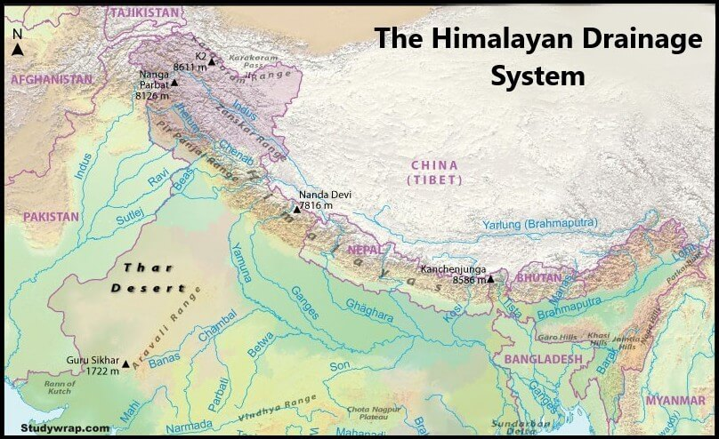
Himalayan rivers are the most important part of the Indian drainage system. They are perennial i.e. they always have water. These rivers receive water from melted snow as well as from rains. These rivers form V-shaped valleys, rapids and waterfalls in their mountainous course (upper course). Erosional activity and uplift of the Himalayas have carved out deep gorges. Thus this is an important aspect of the Indian drainage system.
In the middle and the lower courses (plains), these rivers form meanders, oxbow lakes and many other depositional features in their floodplains. These rivers have a tendency to shift their courses frequently because they carry huge quantities of sediments from its upper reaches and deposit them in the plains. So whenever the course gets blocked, the river changes its course. e.g, river Kosi (“sorrow of Bihar”), is known for changing its course frequently.
Himalayan Drainage System
The Indus, the Ganga and the Brahmaputra systems are the three major river systems of the Himalayan drainage system.
Indus River System
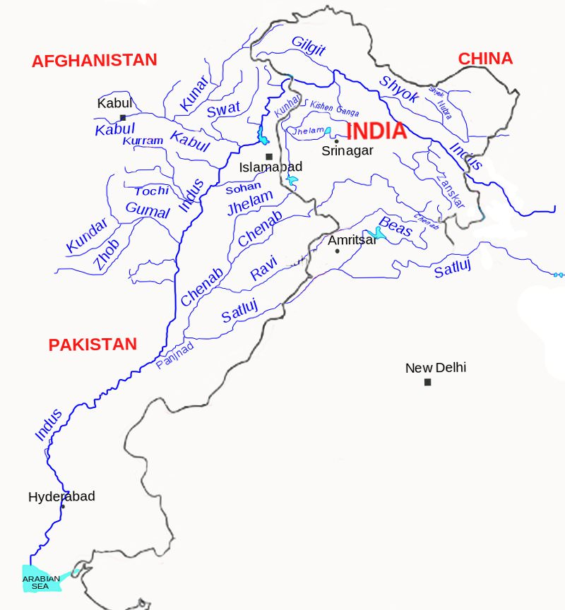
- Though politically not a part of Indian drainage system, but geographically it is certainly an integral part of Indian drainage system. In Tibet, it is known as “Singi Khamban” or “Lion’s mouth”.
- It is also known as “Sindhu” and is the westernmost of the Himalayan rivers in India.
- Total Length : 2,880 km and in India, its length is 1,114 km.
- Origin: It originates from a glacier near Bokhar Chu, in the Tibetan region at an altitude of 4,164 m in the Kailash mountain range.
Course
- It moves in the north-west direction and enters India in Ladakh (Leh) where it forms a gorge. Several Himalayan tributaries like the Shyok, the Gilgit, the Zaskar, the Hunza and the Nubra join it.
- The Indus flows through Baltistan and Gilgit and emerges from the mountains at Attock where it receives the Kabul river on its right bank.
- The river flows southwards and receives Panjnad (a combined name for 5 rivers) near Mithankot in Pakistan.
- The Panjnad is the name given to the Satluj, the Beas, the Ravi, the Chenab and the Jhelum. The river eventually reaches the Arabian Sea.
Tributaries of Indus River
Satluj
- Origin and Course: It originates at “Rakas tal” near Mansarovar in Tibet.
- It runs almost parallel to the Indus river for about 400 km before entering India.
- Satliuj passes through the Shipki La on the Himalayan ranges and enters the Punjab plains. It meets the Beas river in Hari-ke-Patan in Amritsar, Punjab. After the confluence, the combined river enters Pakistan.
- Satluj is an antecedent river called Langechen Khambab in Tibet.
- The Bhakra Nangal dam is built on this river.
Beas
- Origin and Course: It originates at Kund near Rohtang Pass in Himachal Pradesh. It flows through the Kullu valley (Himachal Pradesh) and forms gorges at Kati and Largi in the Dhauladhar range.
- It enters the Punjab plains where it meets the Satluj near Harike (Punjab). The Beas river flows entirely within India.
Ravi
- Origin and Course: Ravi originates at West of Rohtang Pass, Killu Hills in Himachal Pradesh. It flows through the Chamba valley of Himachal Pradesh.
- Ravi drains the area lying between the south-eastern part of Pir Panjal and the Dhauladhar ranges. It enters the plains of Punjab and runs along the Indo-Pakistan border for some distance.
- It then enters Pakistan to join the Chenab river near Sarai Sidhu.
Chenab
- Origin and Course: It originates at Baralacha Pass in Himachal Pradesh. It is formed by two streams – the Chandra and the Bhaga which meet at Tandi near Keylong in Himachal Pradesh.
- Chenab river is also known as Chandrabhaga. It is the largest tributary of the Indus and flows for about 1180 km before entering into Pakistan.
Jhelum
- Origin and Course: It originates at Spring at Verinag, in the south-eastern part of Kashmir valley, at the foothills of Pir Panjal.
- It flows through Srinagar and enters Wular Lake before entering Pakistan through a deep narrow gorge.
- At Jhang (Pakistan) it joins Chenab.
Ganga River System
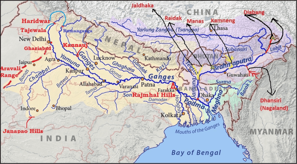
- It would be meaningless to talk about Indian drainage system without the mention of Ganga river system.
- With approx. 2525 km. of length, Ganga is the longest river of India.
- Its basin covers basin covers about 8.6 lakh sq.km in India. It runs through 4 states namely – Uttarakhand, Uttar Pradesh, Bihar and West Bengal. Its source is the Gangotri glacier near Gaumukh of Uttarakhand (Uttarkashi district), here it is known as Bhagirathi. Bhagirathi meets Alaknanda at Devprayag, and thereafter, it is known as the Ganga.
- Alaknanda originates in the Santopanth glacier above Badrinath.
- At Haridwar, the Ganga emerges from the mountains onto the plains where it flows through the 4 states as mentioned above and then enters Bangladesh.
- After entering Bangladesh, the main branch of the Ganga is known as the Padma which meets Jamuna river (largest distributary of the Brahmaputra river).
- Padma river meets Meghna (second largest distributary of Brahmaputra) and hereafter, it is known as Meghna river and enters into the Bay of Bengal.
- Together with Brahmaputra it drains in the Bay of Bengal where it forms the Sundarbans delta that houses the ‘Royal Bengal Tiger’.
Tributaries of Ganga
Tributaries of Ganga can be classified as left bank and right bank tributaries.
Right Bank Tributaries
Yamuna
- With source at the Yamunotri Glacier on the western slopes of the Bandarpunch range (Uttarakhand), Yamuna is the longest and the westernmost tributary of Ganga.
- It joins the Ganga at Prayag (Allahabad). Its main tributaries are Tons, Chambal, Sindh, Betwa, Ken and Chambal.
Tamas River
Its source is Tamakund in the Kaimur Range (Madhya Pradesh). It joins Ganga at Sirsa (Uttar Pradesh).
Son River
- It originates near Amarkantak Hill, (Madhya Pradesh) near the Narmada river and joins the Ganga near Patna in Bihar. Other important river that originates at Amarkantak is the Narmada.
Punpun River
- Originating from the Chotanagpur Plateau region of Palamu district in Jharkhand, it joins the Ganga at Fatwah (Patna).
Left Bank Tributaries
Ramganga River
- It originates in the Garhwal hills near Gairsain (Uttarakhand). Ramganga changes its course to the south-west direction after crossing the Shiwaliks and enters into the plains of Uttar Pradesh near Najibabad.
- It joins the Ganga near Kannauj (Uttar Pradesh). It flows through the Jim Corbett National Park.
Gomti River
- It originates from Gomat Taal (Fulhaar Jheel) near Pilibhit district (Uttar Pradesh). It meets Ganga at Kaithi, Ghazipur in Uttar Pradesh.
- The famous Markandey Mahadev temple is at the confluence of the Gomti and the Ganga.
Ghaghara River
- Ghagra originates in the glaciers of Mapchachungo, near Mansarovar Lake, Tibet. The Sharda or Saryu river which originates in the Milam glacier in the Nepal Himalayas, joins it at Brahma Ghat in India.
- It is the second-longest tributary by length after the Yamuna. Known as the Karnali in Nepal, it is the longest river there.
Gandhak River
- It originates at the Nhubine Himal Glacier in the Mustang region of the Nepal border.
- The Gandhaki river merges with the Ganga at Patna (Bihar). In Nepal it is known by the name Kali Gandaki.
Kosi River
- Often referred to as the “Sorrow of Bihar”. Kosi river branches into distributaries before joining the river Ganga near Kursela in Katihar district (Bihar).
- Arun is its main stream which originates from the northern slopes of Mt. Everest in Tibet (China). After crossing the Central Himalayas in Nepal, it is joined by Son Kosi from the west and Tamur Kosi from the east.
- It forms Sapta Kosi after uniting with the River Arun.
Mahananda River
- Mahananda river joins the Ganga at Godagari Ghat (Bangladesh) and is the easternmost tributary of the Ganga river.
- It rises in the Darjeeling hills of West Bengal.
- Mahanadi flows southwards through the fertile agricultural area of Bihar and enters into West Bengal.
- It then flows in the southeast direction into Bangladesh.
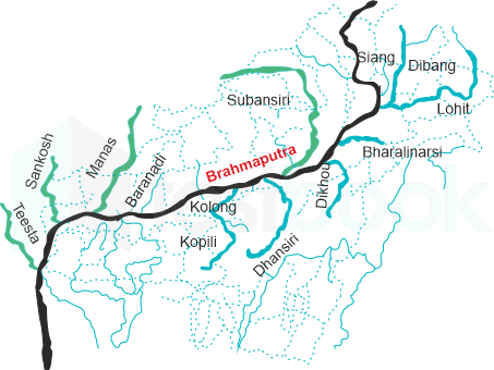
Brahmaputra River System
- Brahmaputra is a trans boundary river and flows through 3 countries – China, India and Bangladesh.
- It originates at the Chemayungdung glacier of the Kailash range near the Mansarovar Lake.
- It flows eastwards longitudinally for a distance of nearly 1,200 km in a dry and flat region of southern Tibet, where it is known as the “Tsangpo”, which means “the purifier”.
- The Rango Tsangpo is the major right-bank tributary of this river in Tibet.
- It emerges as a turbulent and dynamic river after carving out a deep gorge in the Central Himalayas near Namcha Barwa, 7,755 m (eastern part of the Himalayas).
- River Brahmaputra is a combination of Dihang, Lohit and Dibang rivers when it enters Assam.
- Due to a low gradient, river Brahmaputra is a highly braided river.
- Thus it forms a number of riverine islands. Majuli (Assam) is the largest river island in the world which lies in this river.
- Major left-bank tributaries of the Brahmaputra river – Burhi-Dihing and Dhansiri.
- Major right bank tributaries of the Brahmaputra river – Subansiri (Gold river), Kameng, Manas and Sankosh.
The Peninsular Rivers Of India Map
- An important notable point for the peninsular rivers is that the Peninsular drainage system is older than the Himalayan one. Peninsular rivers are not perennial like the Himalayan rivers.
- Most of the Peninsular rivers are seasonal, as their flow depends largely on the rainfall of the region.
- They have shorter and shallower courses as compared to the Himalayan rivers. Important peninsular rivers are: Narmada, Tapi, Chambal, Sindh, Betwa, Ken, Son, Mahanadi, Godavari, Krishna and Kaveri.
- Thus, due to the presence of a number of rivers, the peninsular rivers are an integral part of Indian drainage system.
Important west flowing peninsular rivers
Narmada river
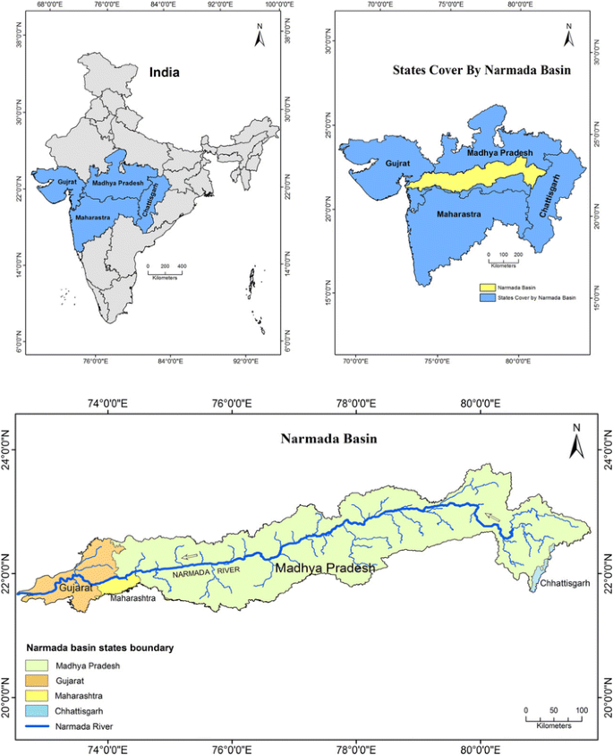
- Narmada originates on the western flank of the Amarkantak plateau.
- It flows in a rift valley towards the west between the Vindhya range in the north and the Satpura range in the south. Narmada houses the ‘Dhuandhar Falls’ in Jabalpur.
- It drains into the Arabian sea near the Gulf of Khambhat, south of Bharuch city of Gujarat and forms a broad 27 km estuary (unlike east-flowing rivers which form deltas).
- It is the longest west-flowing river in India and the largest flowing river of the state of Madhya Pradesh.
- The Sardar Sarovar Project is on this river. It is located in the upper reaches of the Narmada river. Kanha National Park is located in the upper reaches of the Narmada river.
- The park has been described by Rudyard Kipling in his famous book “The Jungle Book”.
Tapi/Tapti river
- River Tapi/Tapti originates from Multai in the Betul district of Madhya Pradesh. It also flows in a rift valley parallel to the Narmada but is much shorter in length.
- The river drains into the Arabian Sea near the Gulf of Khambhat. The Ukai Dam has been constructed on this river.
Mahi river
- The Mahi river originates in the Vindhya Range (Madhya Pradesh). It drains into the Arabian Sea near the Gulf of Khambhat.
- Mahi Bajaj Sagar Dam and Kandana Dam have been built on this river.
Sabarmati river
- It originates in the Aravalli Range of the Udaipur District of Rajasthan.
- It meets the Gulf of Khambhat of the Arabian Sea after traveling in a south-west direction across Rajasthan and Gujarat.
- Famous for Sabarmati ashram which had a role in India’s freedom struggle.
Luni river
- Originating in the Pushkar valley of the Aravalli Range, near Ajmer, Luni is the largest river in the Thar Desert of north-west India.
- At its origin, it is known as Sagarmati which meets Sarasvati (which originates from Pushkar Lake) and thereafter, it is called Luni.
- The Luni river is also known as the Lavanavari or Lavanavati, which means “Salt water” in Sanskrit.
Important east flowing peninsular rivers
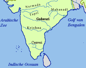
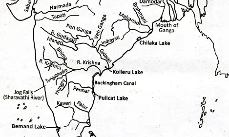
Mahanadi
- It originates near Sihawa in the Raipur district of Chhattisgarh. It runs through Odisha and discharges into the Bay of Bengal. The drainage basin is shared by Maharashtra, Chhattisgarh, Jharkhand and Odisha.
- It houses the largest earthen dam in the world, the Hirakud Dam. Mahanadi was called “the sorrow of Orissa ”, however, the construction of the Hirakud Dam has helped to keep the river well in control.
Godavari
- The Godavari happens to be the largest Peninsular river system and is also called the Dakshin Ganga (Ganga of the south).
- It originates in the Western Ghats of Central India near Nashik in Maharashtra. It flows eastwards and enters Telangana State (in Nizamabad district). Its length is 1,465 km and the drainage system is shared by the states of Maharashtra, Madhya Pradesh, Chhattisgarh, Odisha and Andhra Pradesh.
- The principal tributaries of the Godavari river are Penganga, Indravati, Pranhita and Manjra.
Krishna river
- Krishna is the second-largest east-flowing Peninsular river which originates near Mahabaleshwar in Sahyadri.
- It empties into the Bay of Bengal at Hamsaladeevi, near Koduru in Andhra Pradesh.
- It flows through Maharashtra, Karnataka, Andhra Pradesh and Telangana.
- Its important tributaries are Tungabhadra, Dhudhganga, Koyana, Ghatprabha, Musi and Bhima.
Kaveri/Cauvery river
- It originates in the Brahmagiri range of the Western Ghats, Kogadu district in Karnataka. It flows through the states of Karnataka and Tamil Nadu.
- Total length of the river is about 800 km and the river basin is shared by three states and a Union Territory – Tamil Nadu, Karnataka, Kerala and Puducherry.
- It houses the second biggest waterfall in India known as Shivasamudram Falls.
- The drainage basin of the river receives rainfall during the summer monsoon as well as during the retreating and winter monsoon and therefore, the river carries water throughout the year with comparatively less fluctuation than the other Peninsular rivers.
- The important tributaries of Kaveri are the Kabini, Bhavani, Amravati and Hemavati.
Lakes of India (Indian Drainage System)
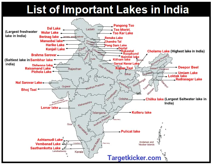
Sāmbhar lake is the largest inland salt lake of India situated in Rajasthan, west of Jaipur. Other salt lakes are Didwana , Degana , Pachpadra , Kuchaman , Lunkaransar etc.
Lonar lake situated in lonar in Maharashtra is a crater lake.
Chilka lake situated in Puri district of Orissa and south of the Mahanadi delta is the biggest lake of the country.
Kolleru lake is a deltaic lake of Andhra Pradesh situated between the Krishna and Godavari delta.
Pulicat lakes situated in the north of Chennai is a shallow lagoon. It has been barred by a long sandpit which is actually SriHarikota Island.
Loktak lake situated in Manipur is the largest freshwater lake in North-East India. Keibul Lamjao, the only floating National park of the country is situated here.
Vembanad lake is a lagoon in kerala which is an important tourist spot. Coconut island is located in it.
Gohna lake situated near Devprayag in Garhwal has been formed by a huge landslide across a tributary of the ganga.
Wular lake & Dal lake are tectonic lakes formed by faulting activity.
Rivers Of India UPSC
Rivers of India and the entire drainage system is an integral part of Indian Geography and an important part of UPSC geography preparation. Questions are regularly asked in both Prelims and Mains. Anyway the knowledge of drainage systems is vital in understanding many aspects of Indian Geography. Many rivers have historical significance as capital cities were built on river banks. Not only this, many landmark monuments were built on river banks. The best example of this is the Taj Mahal built on the banks of Yamuna river in Agra.
Conclusion On Indian Drainage System
The Indian drainage system is extensive and diverse, comprising a network of rivers, lakes, and deltas. It plays a vital role in the country’s agriculture, economy, and cultural heritage. The rivers in India are categorized into two major river systems: the Himalayan rivers in the north and the Peninsular rivers in the central and southern parts.
The Indian drainage system also includes various deltas, such as the Ganges-Brahmaputra delta and the Godavari-Krishna delta. These deltas are fertile and support intensive agricultural practices.
However, the Indian drainage system also faces challenges such as water pollution, over-extraction of groundwater, and inadequate management of water resources. Industrial and domestic waste discharge, agricultural runoff, and improper sewage treatment contribute to the degradation of water quality in many rivers.
Overall, the Indian drainage system is a crucial lifeline for the country, sustaining livelihoods, providing water resources, and nurturing a rich natural heritage. Sustainable management and conservation of these water bodies are essential for the future well-being of the nation
FAQs
What is the drainage system of India?
Drainage system of India refers to the network of rivers and their tributaries. Indian drainage system can be divided into to categories : Himalayan Rivers and Peninsular rivers.
What are the four drainage pattern of India?
Dendritic, trellis, rectangular, and radial are the 4 major drainage patterns in India. Drainage patterns are created on the basis of topography.
See Also
Hydrosphere – Everything you want to know
Tagged InIndian Geography