
Major Landforms Of The Earth

There are a variety of major landforms of the earth that are products of exogenic and endogenic forces and which are collectively known as geomorphic processes. In this article we shall be probing into all the major landforms created by the action of rivers, winds, glaciers and underground water (Karst) in terms of depositional and erosional landforms. Erosion always deforms an existing landform, while deposition always creates a new landform.
Fluvial Landforms (By River Action)

The term fluvial derives from the Latin word fluvius that means river. Thus fluvial landforms are generated due the flow of rivers. They cover an enormous range of dimensions, from small features like rills and streams to large rivers and their drainage basins e.g. Nile and Amazon basins. Most of the continental surface is drained by rivers and streams in a variety of environments except in arid, desert, glacial and Karst regions. Rivers flowing to the oceans drain about 68 % of the Earth’s land surface. The fluvial processes sculpt landforms by erosion and transport the sediments to new areas where they get deposited to create new landforms.
Processes involved in Erosion

Attrition: rock fragments carried by the river strike and roll against each other i.e mutual wear and tear.
Corrasion/ Abrasion: River, along with its bed wears its bed & banks.
Corrosion: The river water dissolves the minerals in soluble rocks.
Hydraulic Action: The sheer weight of the water itself wears away the bed and banks.
Headward erosion: erosion at the origin of a stream channel, which causes the origin to move back away from the direction of the stream flow, leading to increased length of the channel.
Landform in the upper course of the river
Deep narrow V-shaped valley: It is formed as the swift flowing river erodes its bed faster than the sides. Due to steep gradient, the velocity of water flow is very high. Thus it cuts a notch and then the crack gradually widens. The processes of abrasion and corrosion along with freeze – thaw weathering loosens the rocks (some of which will fall into the river) and steepen the valley sides. The rocks accumulated in the river hasten the abrasive action and erode the sides even further. Thus the channel becomes wider and deeper creating a V- Shaped Valley.

Potholes: The grinding of the pebbles caused by the swirling action of water deeper the circular depressions in the river bed forming potholes. A pothole is a cylindrical or bowl shaped hollow that is carved out on the rock beds of watercourses. A plunge pool somewhat similar to a pothole is the deep depression in a stream bed at the base of a waterfall. Plunge pool is also known as a plunge basin or a waterfall lake.

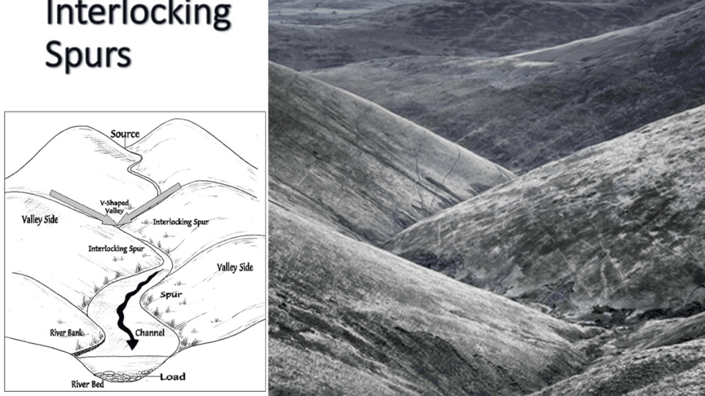
Interlocking /Spurs: It is caused by vertical river erosion where spurs alternate on each side of the river as if they are interweaving. In the upper courses of rivers there are some zones of hard rocks that are difficult to erode. Thus the softer parts erode the harder rocks remain as projections on the sides of the V- shaped valley. These projections when alternate appear in the form of interlocking spurs.
Waterfalls & Rapids: They are formed when the erosion caused by the river steepens its valley suddenly forcing the water to jump or fall over the steep slope or when river water plunges down the edge plateau , e.g. Angel fall on river Churun, a tributary of Caroni in Venezuela highest in the world, Niagra fall ( USA ), etc.

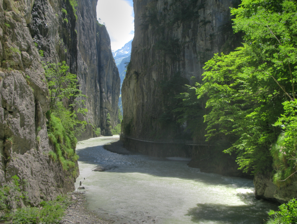
Gorges & Canyons: These are deep, narrow I shaped valleys having very steep sides, formed due to vertical corrosion in the upper course of the river. Canyons are usually found in arid areas and are narrower and deeper than gorges , e.g. Grand Canyon of USA cut by river Colorado. Gorges are special types of canyons which are much deeper and steeper. Most common type of canyon is probably the river canyon. Rivers that lie at the bottom of deep canyons are known as entrenched rivers. These rivers do not meander or change their course.
River Capture or river piracy: The River that is more powerful captures the headwaters of a weaker river by headwater erosion, i.e. towards its source. Over the past 300,000 years, Glaciation is responsible for most river capture events. Other possible events are Tectonic movements.

Features in the Middle Course of the river
U-Shaped valley : An open U-Shaped valley due to valley widening caused by reduced river gradient and velocity. Also known as trough valleys or glacial troughs, they have steep, straight sides and a flat or rounded bottom (by contrast, valleys carved by rivers tend to be V-shaped in cross-section). Glaciated valleys are created when a glacier travels across and down a slope, carving the valley by the action of scouring. It takes anywhere between 10,000 and 100,000 years for a V- shaped valley to be transformed into a U-shaped valley. These valleys can be thousands of feet deep and tens of miles long.

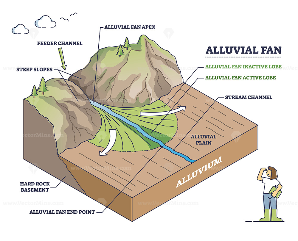
Alluvial Fans : When river debouches from the mountains to the plains, steep fall in river gradient forces the river to deposit its sediment in a fan shape, called alluvial fans. Since the stream suddenly enters a wider area it spreads and deposits its sediments. When they dry up they create Alluvial fans.
Meanders: In the middle course , due to reduced slope and increased volume of water, the river resorts to pronounced meanders.

Ox–bow lakes: It is a crescent shaped lake, once been part of river-meander cut through by lateral erosion of the banks at the meander neck.

Floodplain: A flat tract of land mainly in the middle and lower courses, consists of alluvium deposited by the river.

Natural Levee: In times of flood, sediment is deposited along the banks and in the channels , elevating the channel & the bank. These raised banks are known as natural levee.
Features in the lower courses
Braided Rivers: Due to reduced gradient and sediment-carrying capacity, large amounts of deposited material on the river bed cause the river to divide and move around these barriers, resulting in braiding.

Delta: It is a deposit of sediments formed at the mouth of the river where it enters a lake or sea. Favorable conditions for its formation are :
Large sediment load.
Absence of tides & current capable of removing sediment.
Shallow sea adjoining the delta.
Types of Delta

Arcuate Delta: Fan shaped, convex towards sea, e.g. Nile , Ganga , Hwang-Ho, Rhine, Meckong , Niger etc.
Digitate/Bird’s foot delta: Finger like pattern reflecting the number of distributary streams , e.g. Mississippi river delta.
Estuarine Delta: Develops at the mouth of a submerged river, long and narrow. E.g. deltas of Amazon, Congo, Ob, Vestula, etc.
Cuspate Delta: Tooth shaped symmetrical delta formed over a straight coastline , e.g. delta of Ebro (Spain), Tiber ( Italy )
Glacial Landforms
Glaciers are moving masses of ice. Due to a large mass involved in the movement, they have a huge capacity to erode and transport rock material. The major landforms made through glacial erosion include U-shaped valleys, cirques, hanging valleys, cols, saddles, passes and fjords. The depositional features formed by glaciers include the outwash plains, kames, eskers, drumlins and moraines.
The chief processes involved in glacial erosion include plucking (breaking and uprooting of rocks due to physical force of the moving ice), abrasion (frictional action of ice and rocks embedded in it on the rocks) and attrition.
Erosional Processes
- Abrasion : In it glacier scratches , sours & polishes the valley floor through its debris.
- Plucking : Detaching or tearing away of large particles of rocks by the moving glaciers.
Erosional Landforms

Cirque / Corrie: An armchair – shaped depression surrounded by steep headwall & sidewalls.
Arêtes & Horns: Sharpened peaks resembling sawtooths and formed due to recession cirques on both sides called Arêtes. A pyramidal or triangular – faceted peak formed due to recession of three or more cirques is called horn.
Nunatak: Higher peaks & mounts surrounded by ice from all sides.
Roches Moutonnees ( sheep rocks) : Asymmetrical hillocks having onset side smoothly molded with gentle slope and steeper, rougher lee side. ( Steepened due to plucking)
Crag & Tail: It is a hill having vertically eroded steep up glacial side and tail like down glacial side.
Glacial Stairways: Glaciated benches, separated by nearly vertical cliffs. Smaller depressions at the base of a cliff are called paternoster lakes when filled with water.
Hanging Valleys: These are valleys of tributary glaciers which join the main glacial valley of much greater depth.
Depositional Landforms

Moraine: A ridge like accumulation of material which has been transported and deposited by ice.
Drumlin: Whaleback hillock of glacial drift looking like an inverted boat or spoon having steeper up glacial slope. They are also known as baskets of egg topography.
Eskers: Long, low, narrow, ridges composed of stratified sand, silt & gravel.
Kame: A steep-sided alluvial cone deposited against an ice front.
Erratics: Large rock fragments transported away from its place of origin and deposited in an area of dissimilar rock type.
Outwash Plain: Formed from glacio-fluvial material carried out from in front of an ice sheet by melt stream. It Appears as an extensive accumulation of gravel , sand and silt.
AEOLIAN LANDFORMS (WIND ACTION)
Types of Deserts
- Erg or sandy desert
- Reg or stony desert
- Hamada or rocky desert.

Erosional Processes
- Abrasion: Air currents armed with sand grains scrap, polish or etches away rocks surfaces.
- Attrition: Mutual wear & tear of rock and sand particles.
- Deflation: Lifting and blowing away of loose materials from the ground.
Landforms by wind erosion

- Rock pedestals or mushroom rocks : Mushroom shaped rock pillars which have been eroded near their bases.
- Zeugen: Ridge and furrow landscape formed in horizontal layers of hard and soft rocks.
- Yardanges: Here , of the vertically arranged hard and soft rocks , softer rocks are eroded giving rise to long , narrow corridors , separating the steep-sided over hanging ridges called yardangs.
- Mesas and butters: In rocks composed of horizontal layers of hard and soft rocks , hard stratum forms a flat tabular hill of resistant rock , called mesa. Mesas reduced in area after long period of denudation are called Butte.
- Deflation Hollow: wind erosion excavates the hollow by blowing away the loose material from the surface.
- Inselbergs: An isolated hill rising abruptly from the level ground having steep sides rounded summits.
Landforms by wind deposition

- Sand dunes: They are formed by the deflation action of wind that deposit sand in ridges. Barchan is a famous dune which is of crescent shape or moon shape and a special type of transverse dune. Another type, seif is a longitudinal dune.
- Loess: The fine dust blown beyond the desert limit is deposited on neighboring land as loess. It is a yellow, friable material and is usually very fertile. Noted examples are found in north-west China and parts of the midwest USA.
- Bajadas: It is a depositional feature made up[ of alluvial material laid down by the intermittent streams in an arid environment . An erosional plain formed at the base of the surrounding mountain scarps is called the pediment.
KARST LANDFORMS (UNDERGROUND WATER)
The word karst is a comprehensive term applied to limestone , chalk or dolomite areas. Here most of the landforms are produced by underground water and the diversion of surface waters to underground routes, hence the terminology karst landforms.
Erosional Landforms

- Lapies (Karren): Highly corrugated and rough surface of limestone rocks , characterized by low ridges & pinnacles & numerous solution holes.
- Solution Holes and associated features : Sinkholes or swallow holes are small depressions carved out by solution where chemically active rainwater sinks into the limestone at a point of weakness. Further enlargement of sinkholes to continuous solution results in larger depressions called dolines. Further enlargement leads to the formation of extensive depressions , called Uvala.
- Polje: It is a very large depression with steep sides and flat floor , believed to be formed due to down faulting of rock strata.
- Ponors (Aven): The vertical pipe-like charm or shaft that connects the caves and the swallow holes.
- Blind Valley: The valley of that surface stream which disappears in limestone formation through a swallow hole and the valley looks dry.
- Caverns: Caverns are voids of large dimension below the ground surface. They are one of the most significant landforms produced by erosional work of groundwater in limestone lithology. These caverns are found in India near Dehradun in Uttaranchal (Robber’s cave), in south-western Bihar (Gupta Dham cave), etc.
- Natural bridge:- These are chiefly formed due to collapse of the roofs of the caves.
Depositional Features
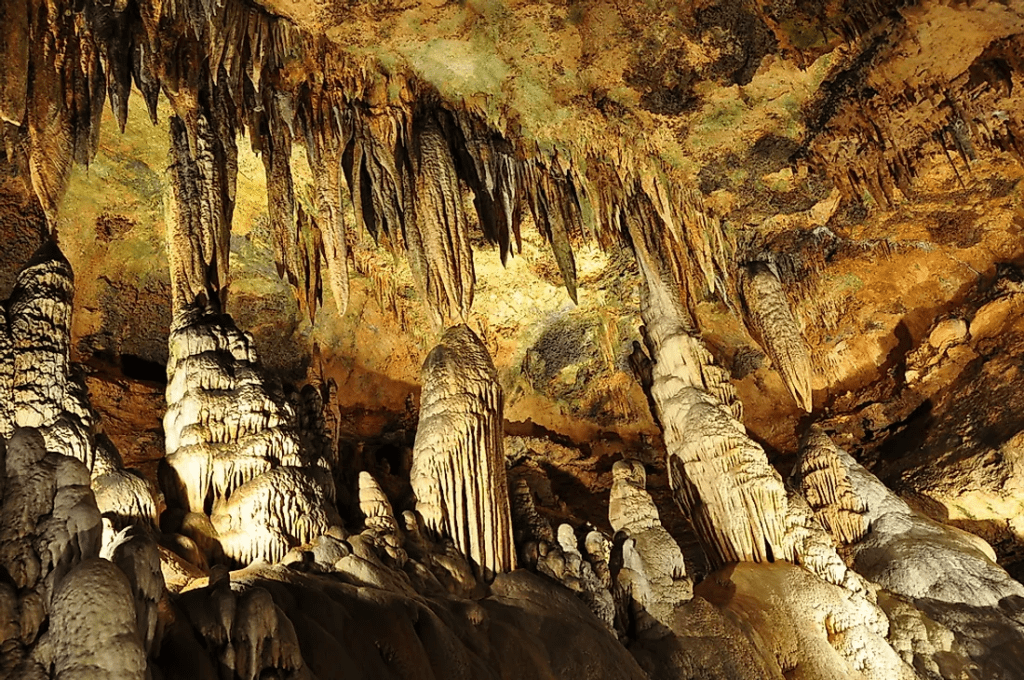
- Stalactites: A tapering pendant of concretion material descending a cave ceiling formed due to deposition of calcareous solutes which are carried by water dripping through the ceiling.
- Stalagmites: The solution that drops on the cave floor is also precipitated and crystallized and forms a columnar concretion ascending from the floor of a cave.
- Pillar: Stalagmites may eventually combine with stalactites to form pillars.
See Also
Exogenic Forces – Weathering, Erosion And Mass Wasting
Endogenic Forces – Folding, Faulting, Earthquakes And Volcanism
Drainage System And Drainage Patters
FAQs
Aeolian landforms can be both erosional as well as depositional.
Erosional : Yardanges, Rock Pedestals, Zeugens, Deflation hollows, Inselbergs, Messas and Butters
Depositional : Sand Dunes, Bajadas, Loess etc.
The term fluvial derives from the Latin word fluvius that means river. Thus fluvial landforms are generated due the flow of rivers. They cover an enormous range of dimensions, from small features like rills and streams to large rivers and their drainage basins e.g. Nile and Amazon basins. These can also be erosional and depositional.
The major landforms made through glacial erosion include U-shaped valleys, cirques, hanging valleys, cols, saddles, passes and fjords. The depositional features formed by glaciers include the outwash plains, kames, eskers, drumlins and moraines.