
What is Hydrosphere?
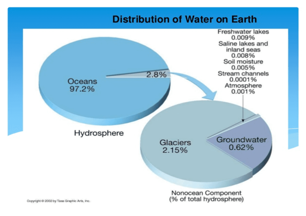
In this article we shall probe in detail what is hydrosphere or the ocean world? Hydrosphere is the sum total of the entire water present on the earth. It thus includes the surface water, the underground water and the water present in the air. Liquid water exists on the surface in the form of oceans, lakes and rivers. The underground water exists as groundwater, in wells and aquifers. In the air water vapor is most visible as clouds and fog.
The frozen part of Earth’s hydrosphere is made of ice: glaciers, ice caps and icebergs. The frozen part of the hydrosphere is known as cryosphere and is made of glaciers, ice caps and icebergs. The hydrosphere along with the cryosphere, atmosphere and the biosphere participate in the global Hydrological cycle. Ever since the evolution of earth, the hydrosphere has had a profound impact on its climate, atmosphere, mineralogy and origin and evolution of life. Thus, the hydrosphere is one of the four major components of earth, the others being atmosphere, lithosphere and biosphere.
Some facts about Hydrosphere
- Oceans extend over 70.8% of the earth’s surface.
- About 60.7% part of the northern hemisphere is covered by oceans while 80.9% surface area of the southern hemisphere is occupied by the oceans.
- Total area of the earth is about 510 million km2 of which about 360 million km2 (70.8%) is represented by the seas & oceans.
- Oceans with their vast extent have a profound impact on the climatic phenomena of the world. They work as the repositories of solar energy. Ocean currents are one of the chief means of the distribution of temperature on the earth. Almost all of the rainfall on the continent is caused by the moisture drawn from the oceans.
- The elevation of the landmasses and the depth zones of oceans are represented by the Hypsographic or Hypsometric curve which shows these regions as a percentage of the area of the globe.
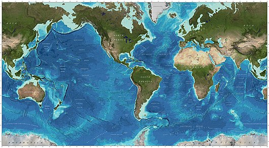
Ocean Bottom Relief – Hydrosphere
The study of the ocean bottom relief features has shed immense light on the origin and evolution of the earth’s crust of which the hydrosphere is an integral part and the theory of plate tectonics. The mean elevation of the land surface is 840 meters while the average depth of oceans is more than 4.5 times, i.e. 3800 meters.
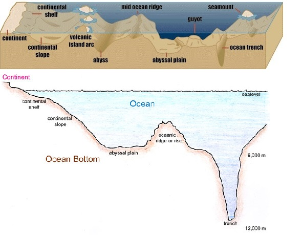
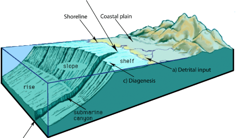
Continental shelf
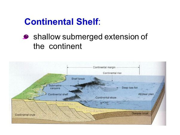
- The shallow submerged extension of the continent is called the continental shelf.
- Average depth-100 fathoms (200 meters) ; average slope-17 feet /mile or about 10.
- Average width is 70 km
- The Continental shelf covers 7.5% area of the oceans. It extends over 13.3% part of the Atlantic Ocean, 5.7% part of the Pacific Ocean and 4.2% part of the Indian Ocean.
- Narrow shelves occur where mountains are found along the coasts e.g. along the Andean coasts.
- The Continental shelf of the western coast of India is wider than that of the eastern coast, mainly because of the subsidence of the western continental part.
- The shelves are almost absent or very narrow along some of the margins like the coasts of Chile, the west coast of Sumatra, etc. [Ocean – Continent Convergence and Ocean – Ocean Convergence].
- It is up to 120 km wide along the eastern coast of the USA. On the contrary, the Siberian shelf in the Arctic Ocean, the largest in the world, stretches to 1,500 km in width.
- Continental shelves represent the rich fishing grounds of the world and they also contain other marine foods, metallic nodules, petroleum and natural gas, etc.
- The continental shelf is formed mainly due to:
- submergence of a part of a continent
- relative rise in sea level
- Sedimentary deposits brought down by rivers
There are various types of shelves based on different sediments of terrestrial origin:
- glaciated shelf (Surrounding Greenland),
- coral reef shelf (Queensland, Australia),
- shelf of a large river (Around Nile Delta).
Importance of Continental shelf:
- Marine food comes almost entirely from continental shelves;
- They provide the richest fishing grounds;
- They are potential sites for economic minerals [20% of the world production of petroleum and gas comes from shelves. Polymetallic nodules (manganese nodules; concentric layers of iron and manganese hydroxides) etc. are good sources of various mineral ores like manganese, iron copper, gold etc..]
Continental Rise
- Average slope – 0.50 to 10 ;
- With increasing depth, it becomes almost flat and merges with the abyssal plain.
- With increasing depth the rise becomes virtually flat and merges with the abyssal plain.
Continental Slope
- Sea wards part adjacent to continental shelves having steep slopes.
- Average slope –20 to 50 ;
- Depth – 200-2000 fathoms ( 3660 metre)
- An important feature of continental slope is the existence of steep submarine canyons on them.
Deep sea / abyssal plains
- Average depth- 3000 to 6000 meters.
- Very low slope gradient ( 1:100)
- Covers 75.9% of total oceanic area including 80.3% of pacific, 80.1% of Indian Ocean & only 54.9% of Atlantic.
- The main reason for the lesser extent of abyssal plains in the Atlantic is the existence of wide continental shelves and slope.
Deep / Trenches
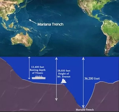
- Deepest part/feature of the oceanic floor.
- Usually parallel to the coasts and island arcs hot in the middle of the oceans;
- Tectonic in origin , represents the site of subducting plate boundaries.
- Mariana trench ( Challenger deep) is the deepest trench in the world situated in the N.W. Pacific oceans.
- They are associated with active volcanoes and strong earthquakes (Deep Focus Earthquakes like in Japan). This makes them very significant in the study of plate movements.
- As many as 57 deeps have been explored so far; of which 32 are in the Pacific Ocean; 19 in the Atlantic Ocean and 6 in the Indian Ocean.
Oceanic Ridges
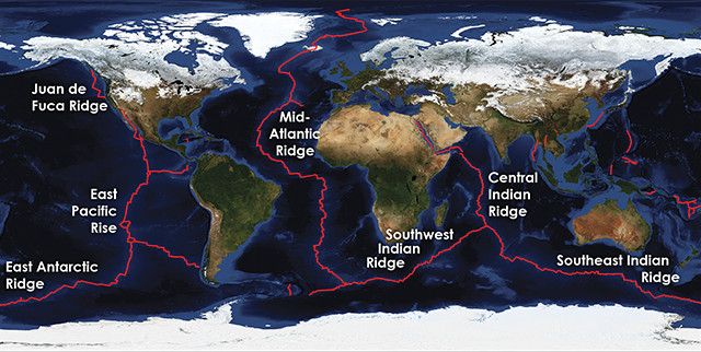
- It is thousands of km long and hundreds of km wide mountain range on the oceanic floor.
- These ridges have been formed by the volcanic activity along the spreading boundary of plates.
- Their summits may rise above the sea level in the form of islands e.g. Iceland, Azores islands etc.
Sea mounts and Gyots

- Sea mounts are submarine hills which rise above the oceanic floor up to 1000 meters.
- Flat topped seamounts are called guyots.
- Both have been formed by volcanic activity.
- Largest number of seamounts and guyots are found in the pacific.
Submarine Canyons
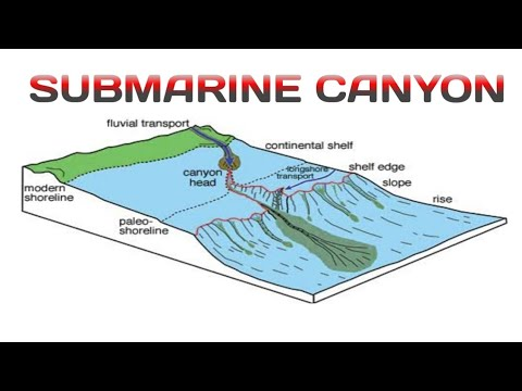
- Deep gorge-like features on the ocean floor are called submarine canyons.
- They are deep valleys having very steep slopes , confining to the continental shelf , slope and rise.
- Many submarine canyons are found along the mouths of major rivers , e.g. –Hudson canyon.
Bank, Shoal and Reef
- Flat topped elevations located in the shelf and slope area are known as bank . Adequate water depth exists for navigation . They represent world famous fishing grounds such as Grand Bank of Newfoundland, Georges Bank ( Atlantic), Dogger Bank( North Sea) etc.
- Detached elevations with shallow depth are called shoals which are dangerous for navigation.
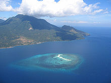
- Coral reefs are formed by the skeletal remains of the coral organisms . These organic deposits are rich in calcareous matter. Many islands are formed by the coral deposits . Great Barrier reef off the N.E. the coast of Australia is the largest one.
Coral Reefs – Beauty of hydrosphere
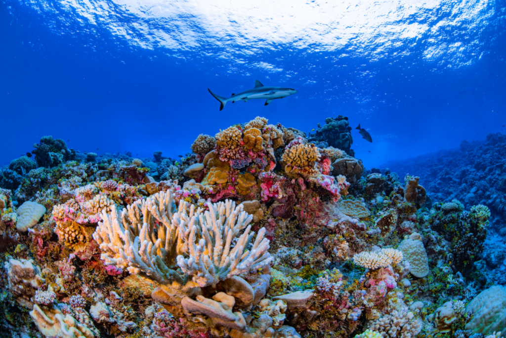
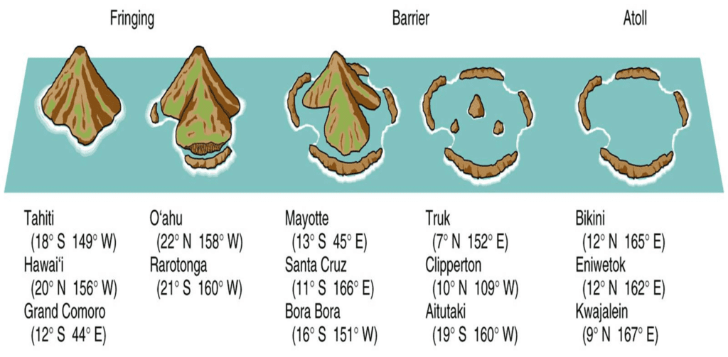
Coral reefs are some of the most diverse and varied ecosystems in the world. It is the Coral reefs that magnify the glory of the hydrosphere. They are massive structures made of limestone deposited by coral polyps. Since they support approximately 25 percent of all known marine species they are often referred to as the “rainforests of the sea” . They provide homes for more than 4,000 species of fish, 700 species of coral, and thousands of other plants and animals. Majority of Coral Reefs are made of hard corals that have stony skeletons made out of limestone that is produced by coral polyps. When these polyps die, their skeletons are left behind and used as foundations for new polyps. Based on their shapes coral reefs are divided into 3 categories :
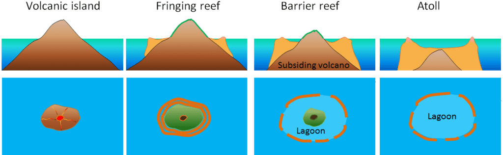
- Fringing Reefs : There are narrow belts of coral reefs developed along the continental margins. They are usually attached to the coastal land but occasionally they are separated from the shore by a shallow, & narrow lagoon called ‘Boat Channel’.
- Barrier Reefs: Largest coral reefs off the coastal plate forms but parallel to them. The reef lies at a distance away from the coast. Hence a broad lagoon develops between the reef & the shore. Great Barrier Reef off the N-E Australia (1200 miles long) is a famous example.
- Atolls: They are circular or horse-shoe shaped , enclosing a lagoon often without any central island. The depth of the lagoon is a few meters with sand and lime stone debris at the bottom. Funafuti atoll of Ellice island is a famous atoll. Faros chains of small atolls having shallow small lagoons. Presently the biodiversity of cords and beautiful reefs are highly threatened by pollution & navigation.
Ocean Temperature
- Usually the temperature of oceanic water ranges from -50 C to 330 C.
- Mean diurnal range of temperature of oceanic surface water is almost negligible ( about 10 C).
- The maximum annual temperature of the northern hemisphere is recorded in August and lowest in February.
- Normally the mean annual range of temperature is 100 F.
- High annual range of temperature is found in land locked seas e.g. 200 F in Mediterranean Sea & 400 F in Baltic Sea.
- The Atlantic Ocean exhibits more annual range of temperature than the Pacific because of its smaller size.
- The warm Gulf Stream current does not allow the Norwegian coast to freeze even in winter.
Horizontal Distribution of Oceanic Temperature
- Temperature of ocean surface water decreases away from the equator.
- Temperature range of about 5.50 C is recorded between 200 N and S latitudes and in the south of 500 S latitude.
- Maximum temperatures are recorded in the enclosed tropical seas e.g. , temperatures up to 380 C have been recorded in the Red Sea.
- In the tropics, the western part of the oceans are warmer than the eastern part due to the effect of trade winds. Likewise in the temperate zone , the eastern part of the oceans are warmer than the western part under the impact of westerlies . Reason is that cooler water below takes the place of surface water which is displaced by the prevailing winds.
Vertical Distribution of Oceanic Temperature
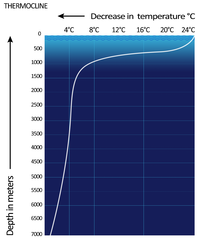
- Normally temperature decreases with increasing depth in the oceans. But the polar regions record inversion of temperature. Here maximum temperatures are found at some depths and after 400 meters the temperature starts decreasing.
- The temperature falls very rapidly up to a depth of 200 meters and thereafter the rate of decrease is slow.
- The change in sea temperature below the 2000 meters depths is negligible.
- The areas from where sea surface water is driven by off shore winds record a lower rate of decreases of temperature with increasing depth (because cooler water upwells from below) and vice-versa.
- The temperature of the ocean bottom is uniform from equator to poles which means that the rate of decrease of temperature is more rapid near the equator than the poles.
Salinity In The Hydrosphere
- Salinity is defined as the total amount of salt particles in grams contained in one kg of sea water and is expressed as part per thousand (0/00).
- Salinity affects the physical properties of the oceans such as temperature, density, pressure, currents etc.
- More saline water freezes slowly while the boiling paint of saline water is higher than the fresh water. Evaporation is lower over more saline water. Salinity also increases the density of water.
- The important types of salts in the sea water in their decreasing order by percentage are : sodium Chloride (NaCL) – 77% , Magnesium Chloride ( MgCl) – 10.9% , Magnesium sulfate ( MGSo4) -9.7% , Calcium sulfate ( CaSo4) – 3.6%.
- Salinity in oceans is derived largely from the landmasses through the work of rivers, winds, coastal erosion etc. Though volcanic activity also contributes.
- The average salinity in the oceans and seas is 350/00, but it spatially varies in different oceans, seas and lakes.
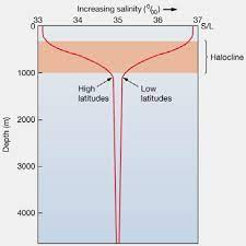
Horizontal and Vertical Distribution of Salinity
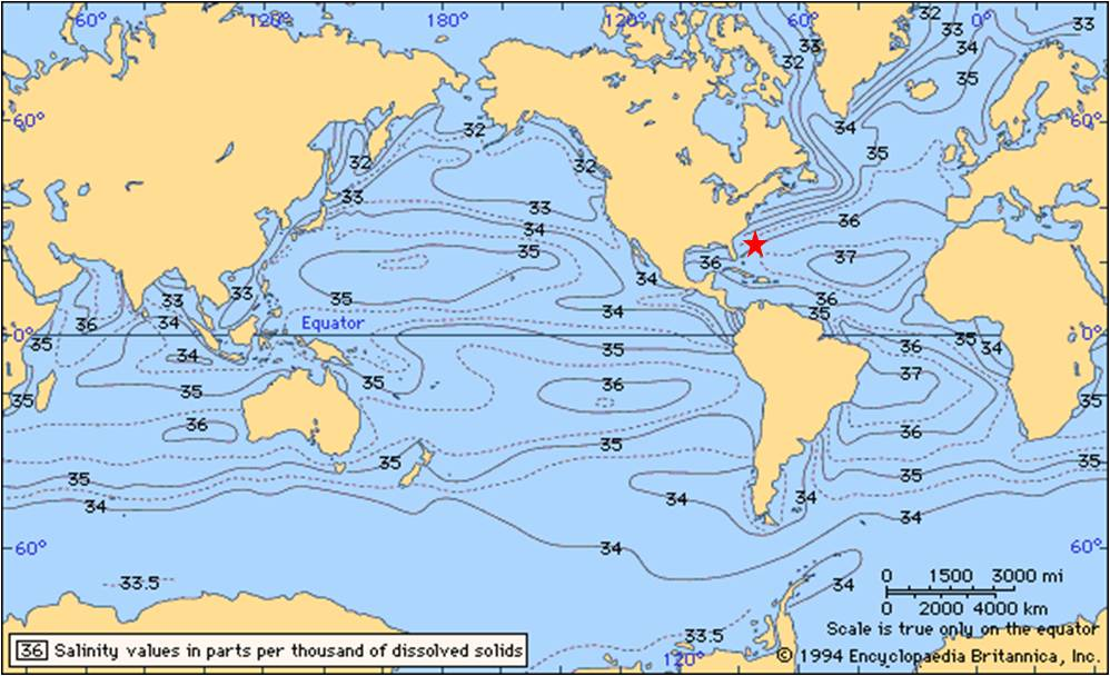
- Generally the salinity decreases from equator towards the poles.
- However , despite high temperature and evaporation , the equatorial region exhibits comparatively lower salinity ( 34 0/00 – 35 0/00 ) because of high rainfall , high relative humidity , cloud sky and calm winds of doldrums.
- The highest salinity is observed between 20-40 Degree North because this zone is characterized by high temperature, high evaporation but lower amount of rainfall.
- The salinity decreases in the zone between 40 and 60 Degree latitudes because of low evaporation caused by low temperature.
- Lowest salinity is found beyond 60 degree latitudes ( polar & sub-polar regions) because of influx of melted water and low evaporation.
- On average the northern and southern hemisphere record average salinity of 34 0/00 and 35 0/00 respectively.
- Marginal seas bordering the continents have lower salinity than their central part because freshwater is added here through rivers.
- Near the mouth of rivers, the salinity is low due to influx of fresh water.
- The amount of salt in inland seas & lakes in controlled by the rate of evaporation, influx of river water and the presence & absence of outlets.
- Very high salinity is found in some inland seas and lakes occurring in tropical region , such as lake von ( 330 0/00, the highest in the world ), dead Sea ( 240 0/00 ) , Red Sea ( 240 0/00 ) , Great salt Lake ( 220 0/00 Utah , USA), etc.
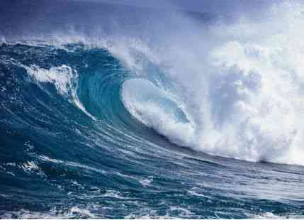
Tides – Hydrosphere
- The rise and fall of sea water due to gravitational forces of the sun and the moon are called tides. They are an important aspect of the hydrosphere.
- The rise of sea water and its movement towards the coast is called tide and the resultant high water level is known as high tide water.
- The fall of sea water and its movement towards the sea is called ebb and the resultant low water level is called low tide water.
Tides vary from place to place because of :
- The change in the position of the sun and the moon in relation to earth.
- Uneven distribution of water over the globe.
- Irregularities in the configuration of oceans.
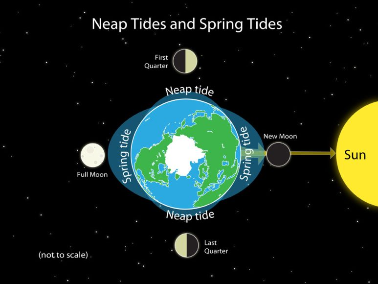
The moon, though a smaller heavenly body, exerts a greater influence on tides because of its lesser distance from the earth than that of the sun. The sun, the moon and the earth come in a straight line on the full moon and the new moon and therefore the gravitational forces of the sun and the moon work together producing a very high tide, called spring tide. The position of the sun, the moon and the earth in a straight line is called Syzygy.
When the sun and the moon are on one side of the earth in a straight line , the position is called conjunction . When the position of the earth is in between the sun and the moon, it is called opposition. They occur during the new moon and full moon respectively.
Neap Tides
The sun, the earth and the moon come in the position of a right angle ( called quadrature ) on the seventh or eighth day of every fortnight of a month and thus the tide producing forces of the sun and the moon work in opposite directions , as a result low tide is caused . Such tides are called neap tides.
Times of Tides
Every place experiences tides, on an average twice a day-one by the gravitational force of the moon and other by the centrifugal force causing outward bulge of the water. A place should experience a tide after 12 hours but this is not the case. Since the earth rotates from west to east and hence the tide center shifts westward. When the tide center completes one round, the moon’s position is ahead of the tide center because the moon also revolves around the earth, with the result the tide center takes another 52 minutes to come under the moon. Hence each day the tide is delayed by 26 minutes.
- Generally tides occur twice a day. But Southampton, along the southern coast of England experiences tides four times a day because the tidal water comes through the English channel and through the north Sea at different intervals.
- Bores are high tidal waves experienced in a narrow river estuary, advancing upstream like a wall of water. In India, tidal bores are common in river Hooghly.
- Ocean Currents
It would be meaningless to study the hydrosphere without the mention off ocean currents. A tide and a current may apparently sound synonymous but in reality there is a fundamental difference between the two. Whereas tide implies transfer of energy, current on the other hand signifies transfer of mass. Ocean currents are patterns of movement of seawater that are continuous, predictable, directional. They are mainly driven by gravity, wind (Coriolis Effect), and water density. Due to this they influence climate zones and weather patterns around the world. Water in the ocean primarily moves in two directions namely vertical and horizontal. While the vertical movement is in the form of upwellings or downwellings, the horizontal movement is in the form of currents.
Some Pointers
- Ocean currents are large masses of surface water that circulate in regular patterns around the ocean.
- The planetary winds have probably the most dominant influence on the flow of ocean currents.
- Between the equator and the tropics blow the trade winds which move equatorial waters westwards and polewards and warm the eastern coast of continents.
- In the temperate latitudes blow the westerlies which result in a north easterly flow of water in the northern hemisphere , so that warm gulf stream is driven to the western coast of Europe as the north Atlantic Drift.
- The earth rotation also deflects ocean currents to the right in the northern hemisphere and to the left in the southern hemisphere . The flow of major ocean currents has been shown in the given figure.
- Coral reefs are masses of lime stone and dolomite accumulated by lime secreting organism known as coral polyps.
Causes of ocean currents
- Pressure gradients
- Coriollis effect
- Frictional forces
- Geostrophic currents
- Ekman layer
Types of ocean circulation – Hydrosphere
At the sea surface, ocean circulation derives its energy from two sources that define two types of circulation – Wind driven circulation and Thermohaline circulation.
Wind driven circulation
This is because of the wind stress on the sea surface that induces a momentum exchange. It is more vigorous as compared to thermohaline circulation and is known as gyres that dominate a particular ocean region. The wind-driven circulation is strongest in the surface layer. A circulation pattern is induced by the wind stress that is similar for each ocean. In each case, the wind-driven circulation is divided into gyres that stretch across the entire ocean: subtropical gyres extend from the equatorial current system to the maximum westerlies in a wind field near 50° latitude, and subpolar gyres extend poleward of the maximum westerlies. In the tropics, the surface currents extend to a depth of less than 1,000 meters. Whereas polar regions the wind-driven circulation reaches all the way to the seafloor.
Ideal Conditions for ocean currents in the hydrosphere
- Tropical oceans and seas having 200-210 C temperature.
- Shallow waters extending to 80 m depth
- Clean sediment free water
- Ocean salinity ranging between 27 0/00 and 30 0/00 .
- Existing submarine platforms.
Conclusion
Overall it can be said that, the hydrosphere stands as a vital and dynamic component of our planet, shaping the Earth’s landscape, climate, and the very essence of life itself. Its vast oceans, rivers, lakes, and glaciers not only provide sustenance for countless organisms but also play a pivotal role in regulating global temperature and weather patterns. However, the delicate balance of the hydrosphere is increasingly under threat due to human activities, such as pollution, over-extraction, and climate change.
As we journey further into the 21st century, it becomes ever more imperative that we recognize the critical importance of preserving and safeguarding the hydrosphere. Conservation efforts, sustainable water management practices, and the reduction of greenhouse gas emissions are paramount in ensuring the continued health and prosperity of both our environment and our society.
Through a shared commitment to protecting this invaluable resource, we can hope to maintain the harmony and balance of the hydrosphere and ensure a sustainable future for generations to come. As we peer into the depths of our planet’s hydrosphere, we find a source of inspiration and responsibility to preserve and protect the watery heart of Earth, for it is in this realm that life truly thrives.
See Also
El Nino UPSC – La Nina, ENSO and Walker Circulation
Climate of India – Classification and Weather
FAQs
Hydrosphere is the sum total of the entire water present on the earth. It thus includes the surface water, the underground water and the water present in the air. Liquid water exists on the surface in the form of oceans, lakes and rivers. The underground water exists as groundwater, in wells and aquifers. In the air water vapor is most visible as clouds and fog.
Hydrosphere is important because it shapes the Earth’s landscape, climate, and the very essence of life itself. Its vast oceans, rivers, lakes, and glaciers not only provide sustenance for countless organisms but also play a pivotal role in regulating global temperature and weather patterns.