
What Is A Drainage System In Geomorphology?

In Geomorphology drainage system signifies the river systems of a particular large area. They are nothing but the patterns formed by the rivers, streams and lakes in a particular drainage basin e.g the Indian subcontinent has a few drainage systems, the major ones being Ganga, Brahmaputra, Indus, Godavari, Mahanadi etc. Any drainage system is governed by some factors such as topography of the land, type of rocks (hard or soft) and the slope gradient. The drainage system of any drainage basin varies on the basis of size and shape of a particular drainage basin. Thus a ‘drainage system’ is the flow of water through a well-defined network of channels.
Depending upon the topography and geology of the land, . There are 2 types of drainage patterns namely Accordant (Consequent) and Discordant (Insequent).
Accordant Or Sequent Drainage System
In his the flow of the river or stream correlates to the structure and relief of the landscape over which it flows i.e. a river or a stream follows the regional topography. Accordingly they can be further categorized as:
- Consequent Streams : The initial streams that originate in a particular region in accordance with the initial slope of the land are called consequent streams.
- Subsequent Streams : The streams originated after the consequent stream and joining the master consequent stream at right angles are called subsequent streams.
- Resequent Streams : Streams which flow in the direction of the initial consequent stream but join in response to a new base level.
- Obsequent Streams: Streams flowing In a direction opposite to that of the dip of the rocks strata, opposite to the master consequent streams.
Discordant or Insequent Drainage System
It is found in streams which do not follow the regional slope and are not adjusted to geographical structure. They are called Insequent streams. The Discordant drainage system is further divided into Antecedent and Superimposed drainage systems.
Antecedent Drainage
Antecedent Drainage
A river that has been able to maintain its direction of flow despite the tectonic uplift of land across its course is known as antecedent river. The word antecedent means something that existed before. Thus, in this case a river has been in existence much before any change in the landscape. If in case there is an upliftment of land due to folding or some other reason, then the river manages to cut through the uplifted landmass. The notable thing here is that the rate of upliftment and rate of cutting through it, is same. Therefore the course of the river remains unchanged even if there is a change in the landscape. Deep gorges through which rivers like Indus, Sutlej, Brahmaputra etc., cross the Himalayas, amply vindicate that they originated before the uplift of Himalayas.
Superimposed Drainage

Superimposed Drainage
In this the landmass existed before the river which is exactly opposite of Antecedent drainage in which the river existed before the landmass upliftment. Here a new river starts flowing over a surface of newly formed rocks. Due to denudation this rock layer is removed and now the river starts flowing over the newly formed surface which is made of older rocks. Thus the river has now superimposed itself on a new surface that is made of older rocks.
Drainage Patterns
Drainage Patterns
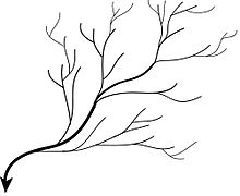
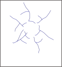
Dendritic Pattern
In it, the network of the streams resembles the shape of a tree with its branches. It is developed on uniform lithology , and where faulting and jointing are insignificant , e.g. massive crystalline rocks or thick clay plains. It is the most common form of the drainage system. Here many sub-tributaries merge into tributaries of the main river. Dendritic patterns are most common in where the rocks beneath the stream can be eroded easily and have no particular structure e.g. rivers of northern plains of India and Caroni River in Trinidad.
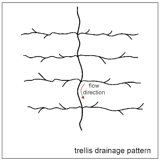
Trellis Patterns
Trellis means a framework of light wooden or metal bars used in gardens to support fruit trees or climbing plants. Some river systems appear like a trellis. These develop in areas where sedimentary rocks due to folding or tilting get eroded to varying degrees depending on their strength. Here a subsequent stream joins the consequent i.e. main stream at right angles. Trellis patterns develops in area where hard and soft rocks occur in roughly parallel bands or in areas of simple folds characterized by parallel anticlinal ridges alternated by parallel clinal valleys, e.g. Appalachian Region of USA.
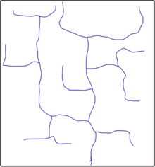
Rectangular Pattern
Though it resembles trellis pattern, it differs from the trellis in that confluence of the tributaries is determined by fault & joints of the underlying rocks and streams are widely spaced and more irregular than the trellis. This pattern develops where rocks are uniformly resistant to erosion and are placed at right angles to each other. Joints of these rocks are stronger than the bulk rocks. Thus the streams tend to flow along the joints.
Radial Pattern
Simply speaking Radial drainage patterns form when rivers originate from a hill or a mountain top and flow in all directions wherever it gets a path. Thus, it is a pattern of out flowing rivers that move away from the central higher point. Streams flow in many general directions. Dome structures, volcanic cones & isolated uplands tend to develop this pattern , e.g. Amarkantak Mountain (source of Narmada river), Hazaribagh plateau, Kathiawar peninsula , Mikir range etc.

Annular Pattern
This pattern , also known as circular pattern, is formed over a mature & directed dome characterized by a series of alternate bunds of hard and soft rocks, guiding the tributaries to take a circular path or a ringlike pattern with a concentric path. It is found where the sedimentary rocks are exposed due to erosion. Also when the stream runs along these rocks e.g. Black Hills in South Dakota and Red Hills.
Parallel Pattern
Here the master and tributary streams are parallel to each other, guided by the pronounced slopes, parallel faults, e.g. streams of western coastal plain of India. It develops in parallel, elongated land forms like outcropping resistant rock bands. It typically occurs in very long, uniform slopes where watercourses run swift and straight, with very few tributaries, and all flow in the same direction e.g. Godavari, Kaveri, Krishna, and Tungabhadra.
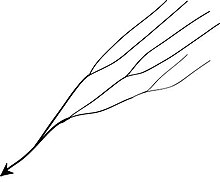
Barbed pattern
Generally developed due to river capture. This pattern comprises tributaries flowing in opposite directions to the master stream. Alternatively the main river which completely reverses its direction of flow, while the tributaries continue to point in the direction of former flow.
Deranged Pattern
Formed in limestone regions where surface streams can disappear into the groundwater via caves and underground drainage routes. They also form in areas of geological disruptions e.g. Canadian Shield area.
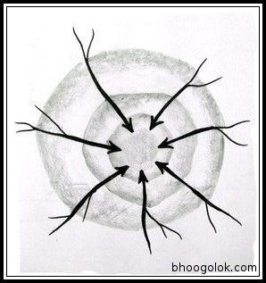
Centripetal Pattern (Drainage System)
These streams flow toward a central depression. It is just the opposite of the radial pattern. This typically happens in lakes surrounded by mountains e.g. Dal Lake in Kashmir.
Drainage Patterns Of India (Drainage System)
Antecedent pattern – Indus , Brahmaputra, Satluj , etc.;
Superimposed pattern – Damodar, Chambal , Banas etc.;
Dendritic pattern –Rivers of Ganga plane ;
Rectangular pattern – Kosi and its tributaries ;
Radial pattern – Amarkantak region, Mikir range, Kathiawar etc.;
Parallel pattern – In west coastal plains and inland drainage in Rajasthan desert area. Western Ghat rivers – Godavari, Kaveri, Krishna, and Tungabhadra.
Conclusion On Drainage System
In conclusion the Drainage System is an essential part of Earth’s hydrological cycle. By this water is transported from higher elevations to lower areas which then eventually is discharged into the oceans through a network of rivers, tributaries and streams. The study of river drainage systems is crucial for understanding the Earth’s water cycle, ecosystem functioning, and human interactions with the environment. By recognizing their importance and taking action to protect them, we can ensure the sustainable use of this vital resource and safeguard the well-being of the planet and its inhabitants.
See Also
Exogenic Forces – Weathering, Erosion And Mass Wasting
Endogenic Forces – Folding, Faulting, Earthquakes And Volcanism
FAQs On Drainage Systems And Drainage Patterns
What is consequent drainage?
Also known as Accordant drainage, in this river follows the general direction of the slope.
What is insequent drainage system?
Also known as Discordant drainage, in this, river maintains its course despite changes in the landscape.