
Pressure And Winds – Introduction
In this article we shall discuss the role of Pressure and Winds in the over weather patterns along with many other details. At the outset pressure and winds seem to be altogether different concepts. But in reality they are intricately related. The primary reason for winds to blow is the pressure differentials that are regularly created on the earth by a variety of reasons. Winds, accordingly blow from high pressure to low pressure areas. Pressure is exerted on the earth’s surface by the overlying weight of the air. The standard air pressure at sea-level 1013.25 millibars. The global air pressure varies from region to region due to combined effect of rotation of the earth and conditions of temperature as follows:
Effect of Temperature
- Low temperature at the poles causes contraction of air and so high pressure is formed.
- High temperature at the equator causes expansion of air, so low pressure called Doldrums low pressure belt is formed.
Effect of Rotation
- As the air moves away from the poles it crosses latitudes that are longer , it has to spread to occupy more space and so pressure falls as at 600 N and s latitudes.
- At the equator the spinning earth causes the rising air to spread towards the pols so it has to cross latitudes which are shorter . So the air has to occupy less space , thus it contracts and sinks at latitudes 300 N and S , forming high pressure.
- Coriolis forces (Ferrel’s Law) : Winds deflected to their right in the northern hemisphere and to their left in the southern hemisphere due to Coriolis force caused by rotation of the earth.
Some important facts related to atmospheric circulation due to Pressure and Winds are:
- The winds are strong where the isobars are closely spaced and weak where they are wide apart.
- Along and near the earth’s surface winds does not move freely in a horizontal plain. The irregularities of the earth surface ( e.g. Mountains, valleys, etc. ) influence the direction of winds.
- The maximum speed of wind usually occurs in the early afternoon and minimum in the early morning.
- Winds are named after the direction from which they come. A wind blowing from west to east is a westerly wind.
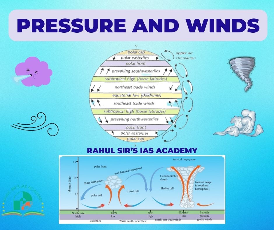
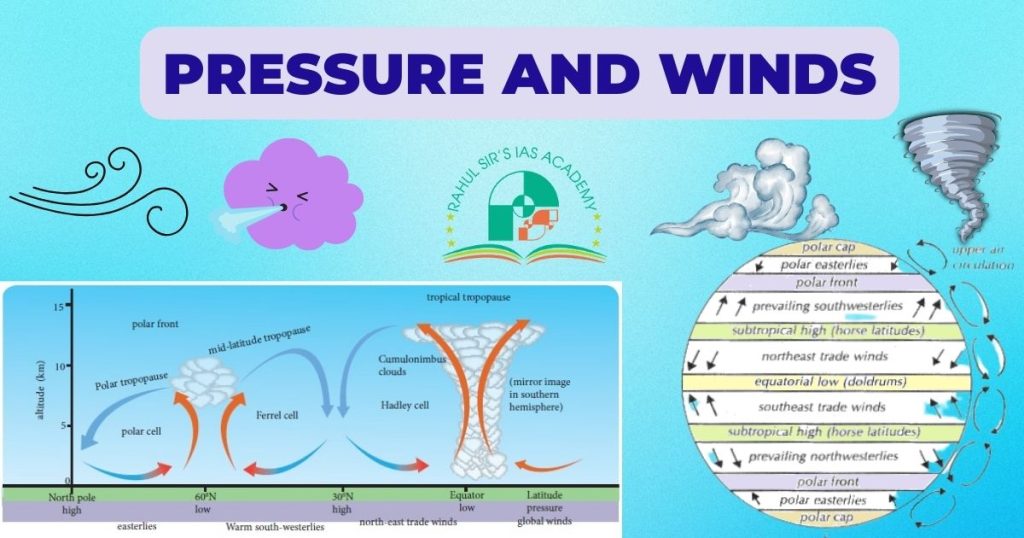
Patterns of pressure Belts & Permanent wind system
On an ideal earth there is close relationship between the pressure distribution and wind systems.
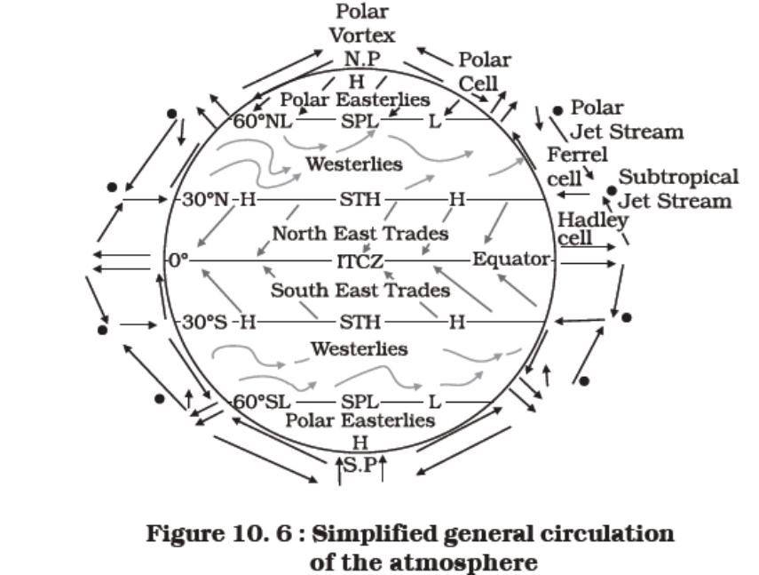
Equatorial low pressure belt – Pressure And Winds
- This is a zone of low pressure caused thermally near the equator. Extending between 50 N and 50 S latitudes, this belt is known as ‘Doldrums’ because of calm winds prevailing here.
- It represents the zone of convergence of North-East and South- East trade winds.
- The calm conditions are because of the absence of Surface winds since winds approaching this belt begin to rise near its margin. Thus, only vertical currents are found.
- Despite calm and light winds the doldrums are characterized by heavy rains , thunderstorms and squalls.
- The position of the belt varies with the apparent movement of the Sun.
Sub-tropical high pressure belts Pressure And Winds
- Extending between 250-300 in both hemispheres , this high pressure belt is dynamically induced by the rotation of the earth and sinking down of winds.
- The upward moving air becomes cold while moving up and becomes heavy at the Tropopause. This air then descends and settles in a lesser area the spherical shape of the earth. Thus a high pressure belt is created.
- The descending air is warm and dry, therefore, most of the deserts are present along this belt, in both hemispheres.
- Known as ‘Horse Latitudes’ , this zone is characterized by anticyclonic conditions which cause atmospheric stability and aridity – one of the main reasons for the existence of hot desert in the western part of continents is this zone.
Sub polar low pressure belts – Pressure And Winds
- Situated between 600 and 650 latitudes in both hemispheres, this low pressure belt is dynamically produced by the rotation of the earth .
- This belt is more regular in the southern hemisphere . The area of contact between cold and warm air masses forms a contact zone , known as polar front, near 600 latitudes.
- Due to winds of contrasting temperatures from subtropical highs and polar lows, this region witnesses temperate cyclones.
Polar High pressure Belts
- The Arctic and Antarctic Polar Regions are the belts of high pressure characterized by permanent anticyclone. Polar easterly winds spiral outward from this belt.
- Extremely low temperature of this region overshadows the effect of rotation of the earth , creating high pressure in this belt.
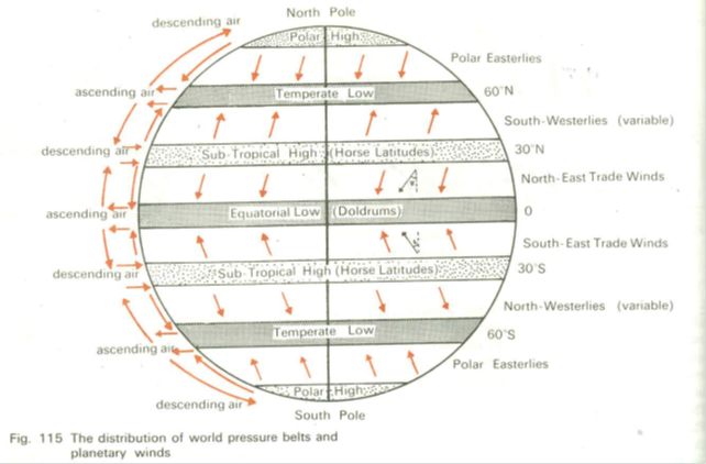
Trade Winds
- They are called trade winds because they are regular winds in direction and force.
- They blow from the subtropical high pressure belt to doldrums.
- In the northern hemisphere , they are deflected to their right to form north-east trades and in the southern hemisphere form south-east trades.
- Between the two trade wind systems is found the Inter Tropical Convergence Zone (ITCZ)
- A zone of westerly winds intervenes between the two trades in the doldrums, called the equatorial westerlies.
Westerlies
- They blow from the horse latitudes to Sub Polar low pressure belt.
- Due to force , their direction is from south-west in the northern hemisphere and from north-west in the southern hemisphere.
- The westerlies become more vigorous in southern hemisphere between 40-60 degrees and are called roaring forties, furious fifties and sheirking sixties in the respective latitudes.
- Where these warm westerlies meet with the cold polar winds , a cyclonic front called polar front is formed and temperate cyclones originate.
Polar Winds
- They blow from polar High pressure to subpolar low pressure.
- Predominance of oceans causes their better development in the southern hemisphere.
- They are easterly winds due to the effect of coriolis force.
- They are generally sporadic and of low velocity.
Jet Streams
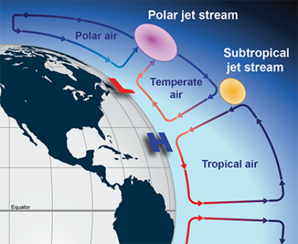
Jet Streams
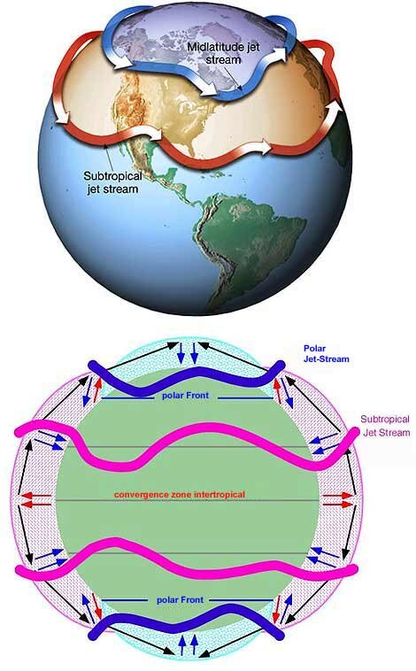
A Jet stream is a very high speed wind blowing from west to east in a meandering course at high altitude, usually near the level of tropopause ( 12 Km.). The speed of the jet stream varies from a mean of 110 Km/hour in summer to 190 Km/hour in winter. It has an important influence in the formation of global climatic phenomena, e.g. Cyclones, variability of monsoons, etc. Thus they impact the pressure and winds.
Cyclones and Anticyclones – Pressure And Winds
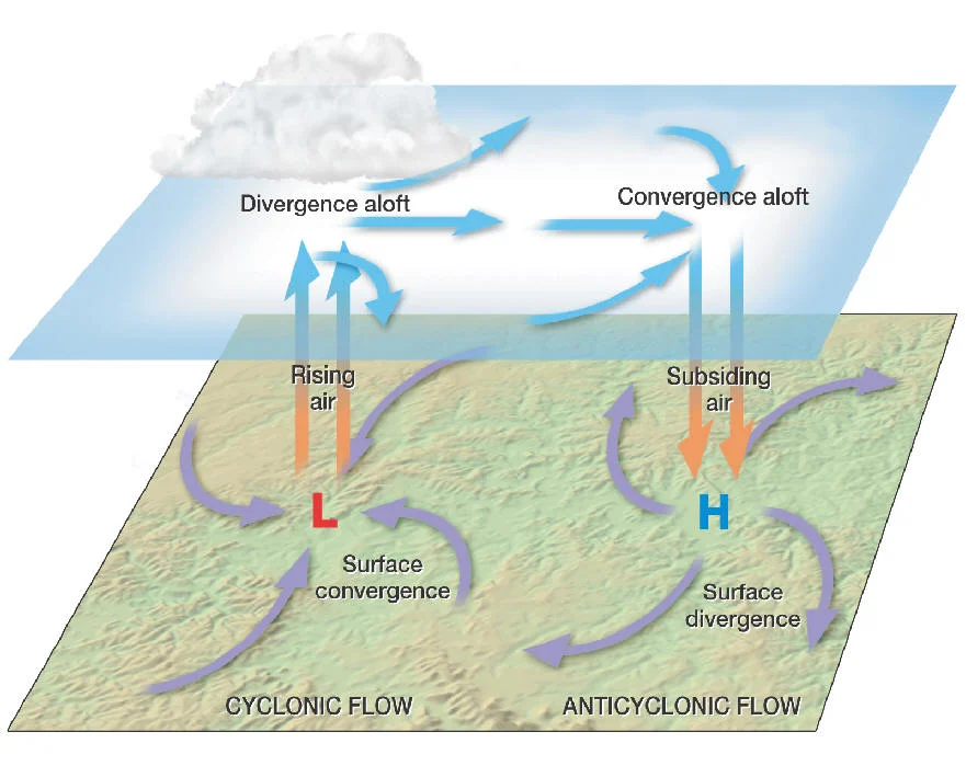
Cyclones And AntiCyclones
Cyclone
Cyclone is a system of low pressure in which the barometric gradient is steep. In a cyclone, winds circulate blowing inward in an anti-clockwise direction in the northern hemisphere and in a clockwise direction in the southern hemisphere.
- Temperate Cyclones: These are cyclones of temperate latitudes caused by contrasting cold air from polar regions and warm moist air from tropical regions. Their general direction of movement was from west to east along the westerlies. The rainfall is light to moderate which occurs in the form of light showers.
- Tropical cyclones: It is a system of a low pressure occurring in tropical latitudes . They originate, unlike temperate ones , only over ocean , in the equatorial belt of calm when this belt ( doldrums) is at its farthest limit from the equator . They are characterized by the steep pressure gradient thereby having greater wind velocity and hence more destructive than temperate cyclones. They move westward through the trade wind belt.
Anticyclones
Anticyclones : These are characterized by the system of high pressure in the center. The pressure and winds are accordingly distributed. The isobars are generally widely spaced, indicating light winds. The associated weather is settled and stable, generally warm, sunny and dry in summer and cold, frosty and clear in winter. In the northern hemisphere, the wind circulation is clockwise and anticlockwise in the southern hemisphere.
HUMIDITY, CLOUDS & PRECIPITATION – Pressure And Winds
- Humidity: The water vapor content of air is known as humidity. Warmer air has a greater capacity for holding water vapor whereas cooler air has a lesser capacity.
- Relative Humidity: Relative humidity is the ratio of water vapor actually present in the air to the maximum water vapor holding capacity of the air at that temperature , expressed as a percentage .Thus,
Actual water vapor content of the air
——————————————————————- * 100
Max water vapor holding capacity of the air
Therefore, whereas the temperature is directly related to the water-holding capacity of the air, the temperature and relative humidity are inversely related.
- Dew Point: Air is said to be saturated if it is holding all the water vapour it can hold at a given temperature (100 percent relative humidity). The temperature at which a given mass of air becomes saturated is termed as the dew point.
- Absolute Humidity: The amount of water vapor present in a unit volume of air is called absolute humidity. It is expressed as gram /m3.
- Specific Humidity: The mass of water vapor contained in a unit mass of air is termed as specific humidity. It is expressed as grams of water vapor per kilogram of air.
The Adiabatic Processes
- As we know , the normal lapse rate is the average decrease in temperature with increasing elevation (6.40 C / 1000 meter or 3.50 F / 1000 feet).
- But this rate can vary under diverse weather conditions and so the actual lapse rate at a particular place and time is termed as environmental lapse rate. In contrast to these processes, changes can occur in a parcel of air without a loss or gain of heat, i.e. by adiabatic processes.
- Here an ascending parcel of air tends to cool by expansion, responding to the reduced pressure at higher altitudes. Likewise, descending air is heated by compression.
The rates of adiabatic processes are of two types:
- Dry Adiabatic Lapse Rate L: It is the rate at which dry air cools by expansion or heats by compression, depending upon their ascent respectively. DALR is 100 C per 1000 meters.
- Wet Adiabatic Lapse Rate: It is the rate at which moist ascending air cools by expansion . This rate varies according to the moisture content of the air but roughly it is 60 C/1000 meters for saturated air. WALR is lower than DALR due to release of latent heat of condensation during cooling of saturated air.
Clouds – Pressure And Winds
A cloud is an aggregation or grouping of moisture droplets and ice crystals that are suspended in air and are great enough in volume and density to be visible to the naked eye. Dust particles act as hygroscopic nuclei for the formation of cloud particles.
Types of clouds
- Low clouds ( from the surface to 2000 meters )
- Strata cumulus clouds – arranged in globular masses.
- Stratus clouds – resembles fog, comprise uniform layers, appear dull.
- Nimbostratus – known as rain clouds , dark & thick enough to beot the sun . The term nimbus is associated with any cloud that gives rain.
- Middle clouds ( from 2000-6000 meters )
- Altostratus – in the form of a continuous sheet or veil.
- Altocumulus – a grayish sheet cloud.
- High clouds (Above 6000 meters)
- Cirrus clouds – long-drawn-out wisps, known as mare’s tails are produced , delicate fibrous or wispy clouds consisting of tiny spicules of ice , an indication of an approaching cyclone.
- Cirro-stratus clouds – whitish in color, produce solar or lunar ‘Halo’.
- Cirrocumulus clouds – in the form of ripples, known as Mackerel sky.
- Clouds with considerable vertical development
- Cumulus clouds – a convention cloud, have ‘cauliflower heads’, appear puffy like ‘cotton balls’.
- Cumulonimbus clouds – cloud with a considerable vertical extent, its top acquiring an ‘anvil shape’, usually associated with heavy precipitation and thunderstorms.
- The amount of cloud cover in the sky is expressed in eighths or oktas such as 2/8 (quarter covered), 4/8 ( half cast ),etc.
Forms of Precipitation – Pressure And Winds
- Rain: In it the liquid water particles fall with the drops of more than 0.5 mm diameter.
- Drizzle: Drops of water are fine less than 0.5 mm of dia.
- Snowfall: Fall of white and opaque grains of ice.
- Sleet: When water droplets and snow all combine, it is called sleet.
- Hail: It refers to falling of small pieces of ice with a diameter of 5 to 50 mm.
Types of Rainfall – Pressure And Winds
- Convectional Rainfall : Due to intense heating moisture laden air rises, expands and thereby cooled adiabatically below the dew point. This results in heavy rainfall generally by cumulonimbus clouds. This type of rainfall generally occurs in the equatorial climate where constant high temperature and high humidity produces rainfall almost daily in the afternoon. In the temperate regions convectional rainfall occurs in early summer.

- ,Orographic Rainfall: Moisture-laden winds are forced to rise with the slope of the mountain and the air gets cooled adiabatically, causing rainfall on the windward side of the mountains. The leeward side of the mountain becomes a rain-shadow area . Orographic rainfall is larger than any type of rainfall in the world.

- Cyclonic or Frontal Rainfall: These rains associated with the passage of a cyclone or depression and are caused by a warm moist air mass moving upwards over colder heavier air. It usually occurs in the middle and high latitudes.

Distribution of precipitation – Pressure And Winds
- The mean annual precipitation for the entire earth is about 100 cm.
- Heavy rainfall occurs on both sides of the equator up to 100 latitudes.
- Between 10-20 degree latitudes in both hemispheres, trade winds cause rainfall in the eastern parts of the continents because they come from the oceans. But as they move westwards they become dry.
- Subtropical zone of minimum rainfall extends between 20-300 latitudes where descending air induces high pressure and anticyclone conditions not conducive for rainfall. All the tropical hot desert are located in this zone.
- Between 30-48 degree latitudes rainfall occurs on the western margins of the continents in the winter because this zone comes under the influence of onshore westerlies in the winter due to shifting of the pressure belts towards equator.
- Mid-latitudinal zone of high rainfall extends between 40-500 latitudes in both hemispheres where rainfall occurs through westerlies and temperate cyclones.
- Precipitation decreases from 600 latitudes poleward in both hemispheres.
Other Forms – Pressure And Winds
Fog: Fog is regarded as a layer of cloud on the ground, with visibility reduced to less than 1 Km. The cause of fog is the condensation of water vapor in the lower layers of the air due to cooling of the air below its dew point mainly through radiation from the earth’s surface. Favorable conditions for the formation of fog are
- Very light wind and
- A clear sky at night.
Haze: It is a state of obscurity in the lower layers of the atmosphere due to the presence of a large number of condensation nuclei such as dust , smoke or salt spray.
Smog: it is a special case of fog that is heavily laden with smoke or similar atmospheric pollutants. It frequently occurs in industrial cities and densely populated urban areas . Intense smog can be a major health hazard.
Dew: When terrestrial radiation from the earth cools the lower layers of air below dew point, the water vapor condenses into drops on the ground surface , grasses , leaves etc. In the form of dew.
Frost: Moisture on the ground surface condenses directly into ice, i.e. When condensation occurs below freezing point. Frosts are usually harmful for the crops.
Conclusion
Overall we can say, that the intricate dance of pressure and winds is a fundamental aspect of our planet’s dynamic atmosphere. From the relentless trade winds that shape tropical climates to the mesmerizing swirls of cyclones and anticyclones, understanding the forces at play in our skies is vital for meteorologists, climatologists, and anyone interested in the ever-changing world around us. The interplay between high and low-pressure systems, driven by the Earth’s rotation and the sun’s heating, leads to the diverse weather patterns we experience daily. Furthermore, the study of pressure and winds not only enhances our predictive capabilities for weather forecasting but also sheds light on the broader implications of climate change and its impact on atmospheric circulation.
As our planet faces ongoing environmental challenges, the relationship between pressure and winds becomes increasingly important. The potential shifts in atmospheric circulation patterns and the influence on regional climates are areas of active research, and our growing understanding of these complexities is crucial for mitigating the impacts of a changing climate.
In essence, the study of pressure and winds is not just a scientific endeavor but also a practical one with far-reaching consequences. From the sailor navigating the open sea to the farmer tending their crops, and from the climate scientist modeling future scenarios to the curious observer gazing at the sky, we are all influenced by the mesmerizing interplay of pressure and winds. It is a subject that continues to capture the imagination and underscores the inextricable link between Earth’s dynamic atmosphere and the intricate web of life it supports.
See Also
The Atmosphere – Structure And Composition
Hydrosphere – Everything you want to know
Climate of India – Classification and Weather
FAQs
There is an intricate relation between pressure and wind as winds blow only when there is a pressure differential. More the pressure differential, stronger the winds.
When there is a difference in the pressure of two areas, a gradient is created and the air moves from high pressure area to the low pressure area just the way water moves down the slope.