
Introduction to Physical Geography of India
Study of Physical Geography of India is intriguing as well as interesting because of the fact that it is as diverse and varied as the culture of India. Physical Geography of India has its own uniqueness because it has almost all types of landscapes, topographies, vegetation and climates. Thus Physical Geography of India has to be studied in various categories namely – Geology, Physiography, Drainage System, Climate, Vegetation, Soils, Flora, Fauna and Economic and Human Geography. In this article we shall be focusing on Geological and Physiographical aspects of India.
India
India that is Bharat , has been a distinct geographical and geopolitical unit since ancient times. Bounded by the young folded mountains in the north-west, north and north-east and washed by the waters of the Indian oceans in the south , India occupies the most important part of the south Asian realm. India is the only country after which an ocean has been named, that is Indian ocean. This region may gain geopolitical and geo-economic importance in the near future, if organized on the pattern of Asia pacific region or European Economic Community.
Size and Shape
India is the 7th largest country in the world after Russia, China, Canada, USA, Brazil and Australia. India commands a total geographical area of 3287263 square km. Which is roughly 0.57% of the area of the earth and 2.4% of the total area of the land. This 2.4% of the land area is occupied by 16% of the world population making India the second most populous country in the world. India has roughly a quadrangular shape. It measures about 3214 km , from north to south and about 2933 km from east to west . So, the north-south extent is 281 km more than the east-west extent. Thus the size and shape of India is a unique feature of Physical Geography of India.
Location
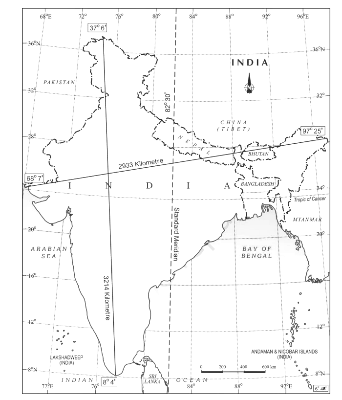
India lies in the northern and eastern hemisphere of the globe between 804’ North and 3706’North latitudes and 6807’ East and 97025’ East longitudes. In south, the southernmost extent goes up to 6045’ north latitudes to cover the last island of the Nicobar group of islands known as Pygmalion point or Indira point. With almost 30 degrees of longitudinal extent the country may be divided into two zones but India has adopted only one standard meridian that is 82030’ east longitude to determine Indian standard Time (5 ½ hours ahead of G.M.T.). The Tropic of Cancer divides the country into two equal halves, the southern halves falling under the torrid zone and the Northern halves forming a sub-tropical zone.
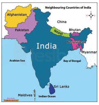
India’s neighbours include Pakistan and Afghanistan in the west, China, Nepal and Bhutan in the north and Bangladesh and Myanmar in the east. In the south, the narrow Palk strait separates the Indian mainland from Sri Lanka. The total land frontier of India is 15200 km. Apart from that India has a mainland coastline of 6100km and total coastline 7516 km. (including the coastline of Andaman Nicobar and Lakshadweep island)
Structure of India – Physical Geography Of India
The study of Physical Geography of India begins with the study of rock structures. These rock structures are not only of diverse types but also they belong to different eras.
Archaean Group Of Rocks
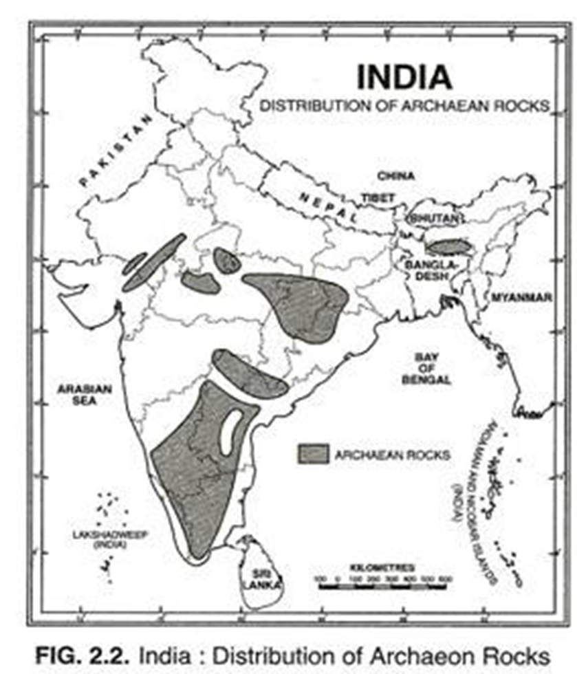
- The geological history of India beings with this group of most ancient rocks.
- These rocks have been formed due to cooling and solidification of the primordial crust.
- These are highly metamorphic rocks , so much that they have lost their original characteristics.
- Known as the ‘Basement Complex’ [They are the oldest and forms the base for new layers]
- Archaean rocks are crystalline rocks mainly gneiss and schist which lack fossils.
- Bundelkhand gneiss is the most ancient rock.
- Archaean rocks are found in Karnataka, Tamil Nadu, Andhra Pradesh, Madhya Pradesh, Orissa, Chota Nagpur plateau and south east Rajasthan.
Dharwar Rocks
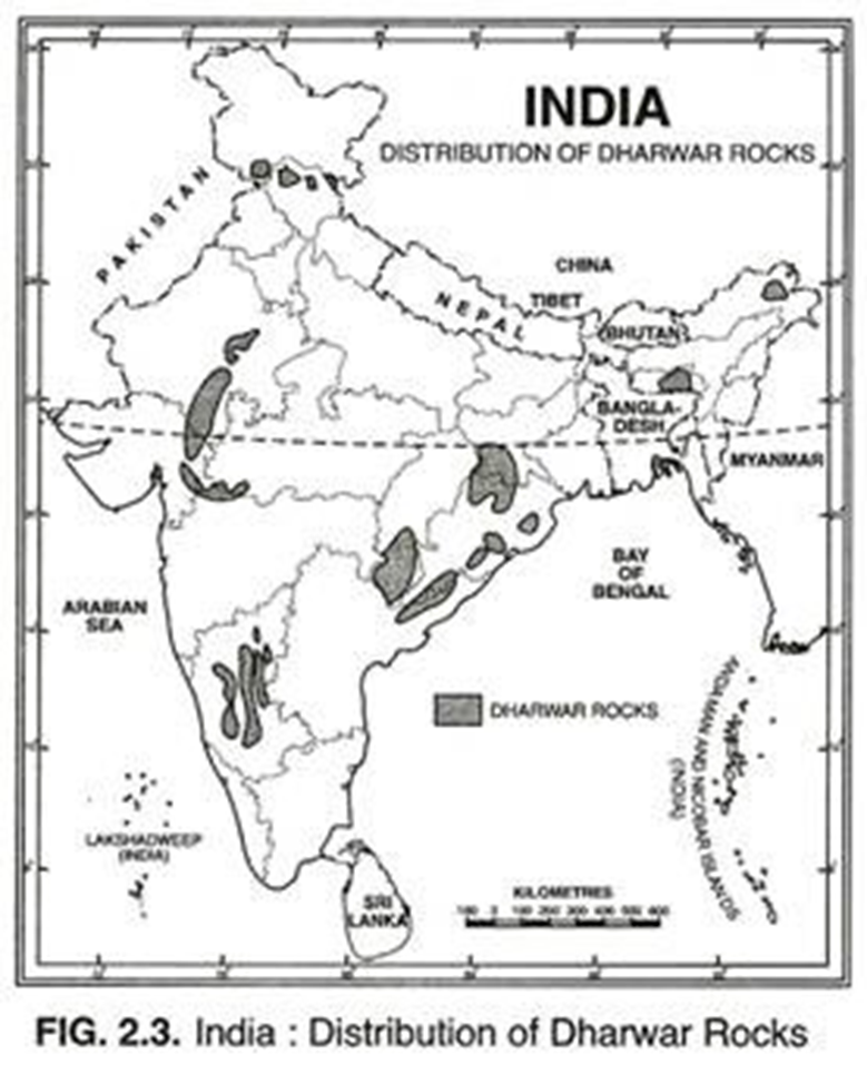
- These are most ancient sedimentary rocks formed from the erosion and deposition of Archaean rocks. They also lack fossils and are highly metamorphosed sedimentary rock-systems.
- Economically, they are the most important rocks because they possess valuable minerals like high grade iron-ore, manganese, copper, lead, gold, etc.
- Aravali mountain has been formed by this group of rocks. Aravali is the oldest mountain in the world.
- Most of the metallic minerals such as iron, gold manganese, copper etc., are found in these rocks.
Cudappa Rocks
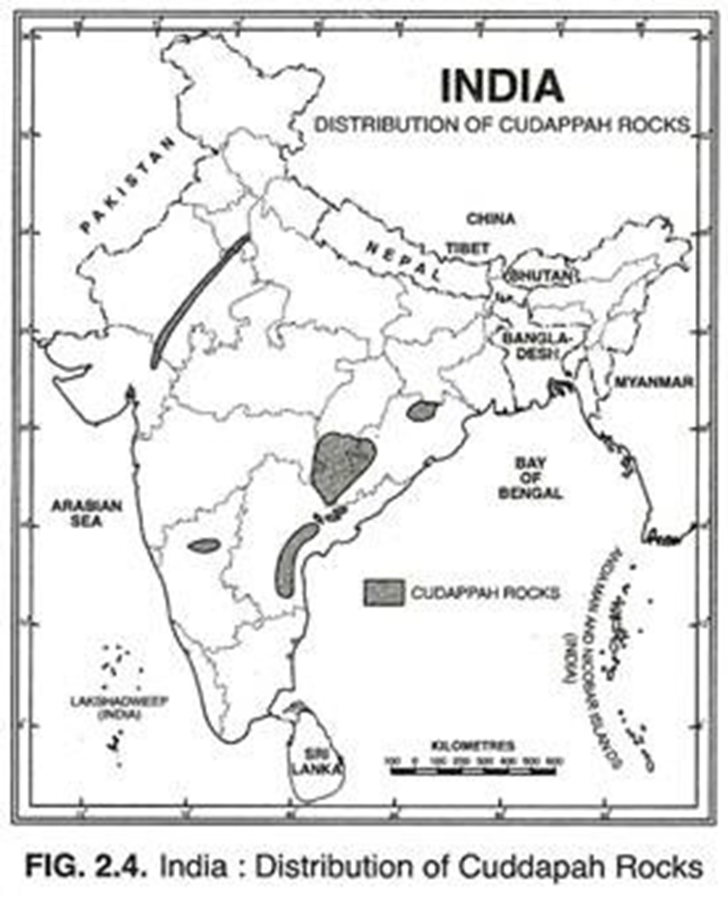
- These rocks have been formed after the erosion and deposition of Dharwar rocks.
- These rocks are noted for their sand stone, limestone, mica, asbestos etc. These rocks contain ores of iron, manganese, copper, cobalt, nickel, etc. They contain large deposits of cement grade limestones.
- The eastern Ghats are made up of these rocks. These rocks are found in the Cuddapah depression ( Andhra Pradesh), the Godavari graben and major parts of Narmada-Son-Damodar graben.
Vindhyan Rocks (1300-600 million years)
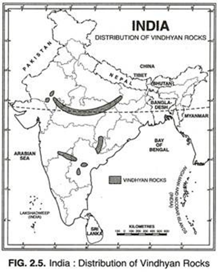
- Vindhyan rocks form a dividing line between rocks cover an extensive area from Chittorgarh in Rajasthan to Sasaram in Bihar.
- The well-known diamond mining areas of Golconda & Panna of the country are associated with the Vindhyan Conglomerates.
- Many historic buildings like Red fort, Agra fort, Sanchi Stupa etc., have been built by the Vindhyan Red Sand stone.
The Gondawana Rocks
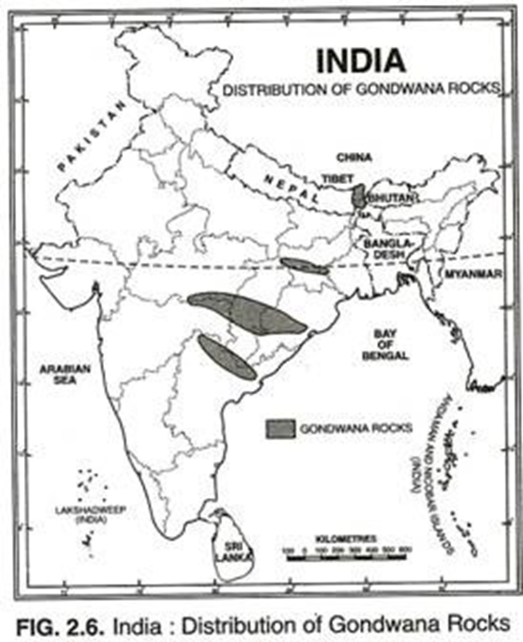
- These sedimentary rocks were formed during the carboniferous period in the trough basins of the peninsula. Formed about 600 – 300 million years ago.
- These basins depressions had countless terrestrial plants and animals which were buried to form coal deposits in India. Abundant fossils are found in these rocks.
- These rocks providing over 90% of the coal of the country are found mainly in the Damodar, the Mahanadi and the Godavari valleys of the peninsular India.
The Cretaceous system
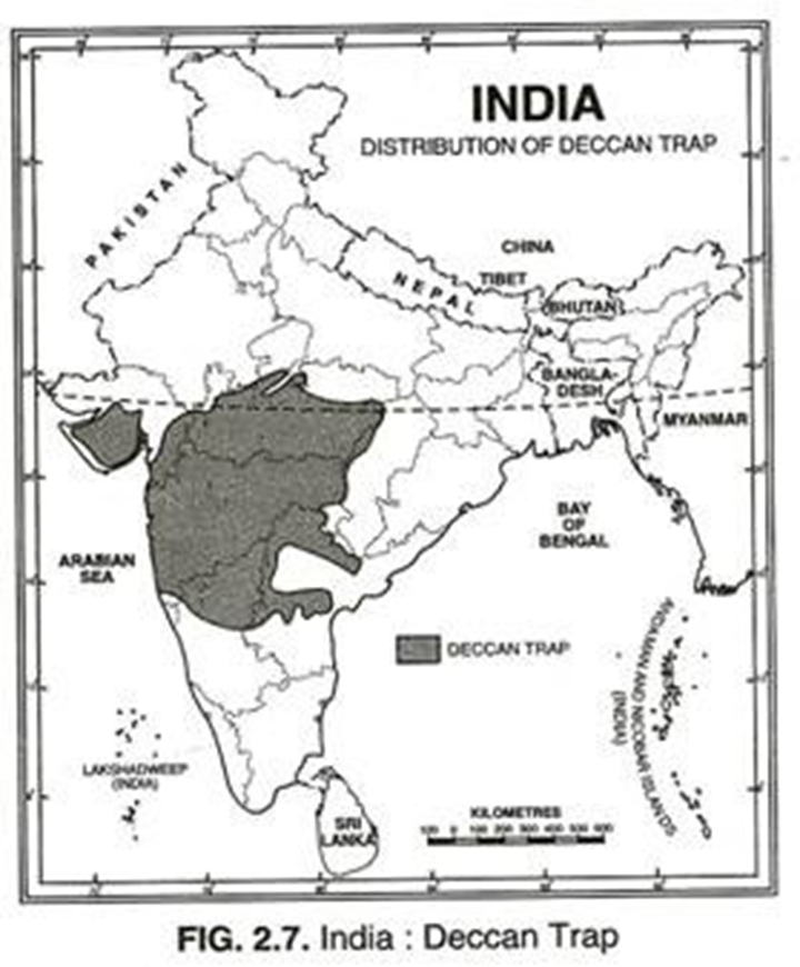
- This system is marked by huge outpouring of basalt in the cretaceous period so as to form a step like sloppy topography called Deccan trap.
- Deccan trap now covers about 5, 00,000 sq. km area in Gujarat, Maharashtra, M.P. & northern Karnataka.
- The decomposition of this basaltic rock has yielded loamy and fertile regur soil which is being utilized for cultivation of cotton, sugarcane & many other crops.
The Tertiary Rocks
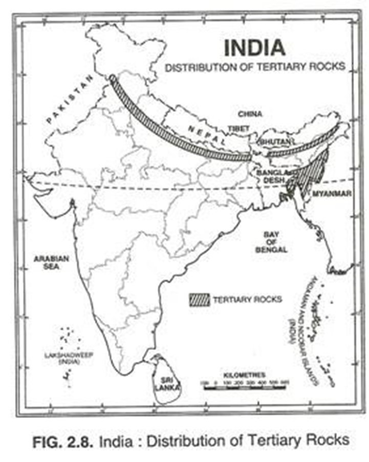
- These rocks are characterized by the uplift of the Tethyan Geo-syncline to form lofty ranges of Himalayas.
- The tertiary rocks contain brown coal rock salt Gypsum and limestone.
The Quaternary Rocks
- The important quaternary formations are ice age deposits in Kashmir, formation of alluvial plains in north India, creation of Rajasthan desert, Runn of Kachh, laterite formation in the peninsula and the formation of Regur soils.
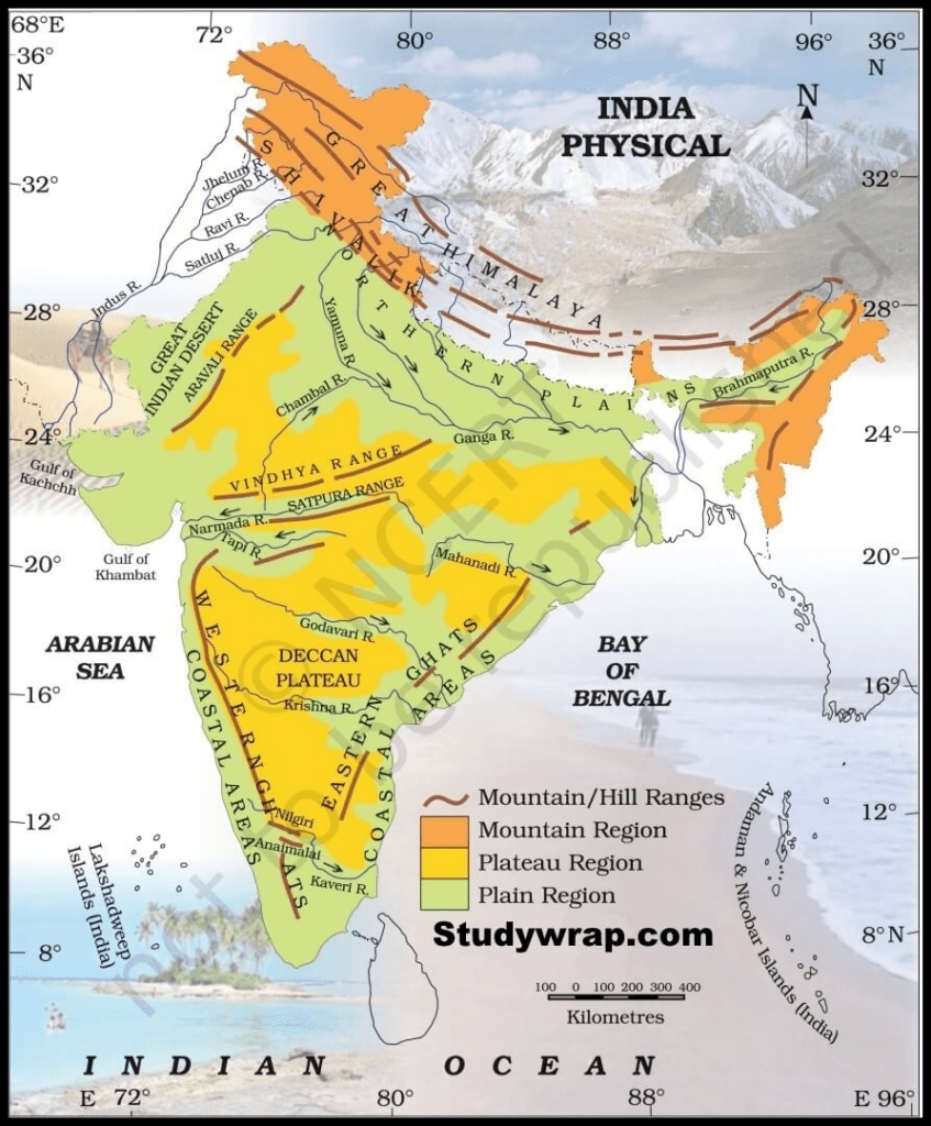
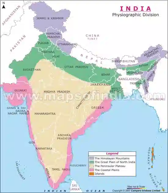
Physical Geography of India – Physiography
- The physiographical aspect of Physical Geography of India is also very interesting as it shows a wide variety of landscapes and topographies. There is a plethora of mountains, rivers, plains, plateaus, islands and lakes.
The Northern Mountains
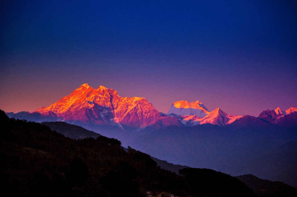
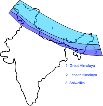
This region of India is marked by the lofty ranges of Himalayas extending all along the northern frontiers of the country, from eastern boundary of Pakistan to borders of Myanmar. Himalayas, the abode of snow, represent the youngest and highest folded mountains in the world. Longitudinally, Himalayas consist of three parallel ranges from north to south. The Himalayas mark the crown of Physical Geography of India.
The Greater Himalayas / Himadri
- This is the most continuous, loftiest and northernmost range of the Himalayas. It has a core of Archaean rocks flogged by metamorphous sedimentary rocks. The average height of Himadri is 6100 meters .
- Here most of the peaks exceed 8000 m, such as Mount Everest-8848 m (the highest peak in the world), Kanchenjunga-8598 m, Makalu-8481 m, Dhaulagiri-8172m etc.
- This range is penetrable through some passes existing at very high altitudes. They are Burzila and Zojila in Kashmir, Bara Lapcha La and Shipkila in Himachal Pradesh, Phagala, Niti pass and Lipu pass in Uttaranchal and Nathula and Jelep La in Sikkim.
- The Hindustan – Tibet road, joining Shimla with Gangtok passes through the Shipkila in Satluj valley.
- An important trade route joins Kalimpong in west Bengal with Lhasa ( capital of Tibet ) through Jelep la in Chumbi valley in Sikkim.
- The Himadri runs in arc shape to a length of 2500 km from Nanga Parbat in the west to Namcha-Bawa in east.
- There exists a number of glaciers of which Gangotri, Milan (Kumaun) and Zemu ( Sikkim ) are important.
- Between Himadari & Himachal exists the famous valley of Kashmir which is a synclinal valley and once the bed of a great lake, enclosed by Pirpa in the south and great Himalaya in north.
- The Kashmir valley is traversed by the north flowing Jhelum River.
- Dal lake near Srinagar is carved out of the alluvial deposits of the Jhelum.
The Lesser Himalayas / Himachal / Middle Himalaya

- To the south of the greater Himalayas lies the middle Himalayas which is separated from the Shivalik range in the south through the main boundary thrust (MBT).
- It comprises parallel ranges in Nepal and Punjab but of scattered mountains in kumaun, the Dhauladhar, Pir-Panjal, Nag Tiba, Mahabharata and Mussoorie range. Of these Pir-Panjal range of Kashmir Is longest one running for 400 km between Jhelum and Beas.
- Two important parks in this range are Pir Panjal and Banihal . The latter is followed by Jammu , Srinagar road. The Kishanganga, the Jhelum and the Chenab cut through the range of Pir Panjal.
- Shimla, Ranikhet, Chakrate, Mussoorie, Almora, Darjeeling, Dalhousie, etc. are situated over the lesser Himalayas.
- The famous hill-resort of Shimla is situated on Dhauladhar range.
- Between Pir-Panjal and Zanskar range of the main Himalayas lies the famous valley of Kashmir.
- The Kangra valley in Himachal Pradesh extends from the foot of the Dhauladhar range to south of Beas river Kangra valley is a strike valley.
- Kullu valley is a transverse in upper course of Ravi river. Eastward of this lies the Kathmandu valley in Nepal.
- Steep bare southern slopes and gentle forests covered northern slopes of Himachal present a typical topography.
- Along slopes of lesser Himalayas are found a number of small patches, called Merg in Kashmir ( e.g. Gulmerg, Sonmerg, Tanmerg) and Bugyal and Payagram Uttaranchal.
The Outermost Himalayas / Shivalik Himalayas
- The Shivalik comprises the southernmost range of Himalayas .
- Overlooking the great plains, this chain of hills runs almost parallel to the lesser Himalayas for a distance of about 2400 km from the Potwar plateau to Brahmaputra valley .
- The altitude varies from 600 to 1500 m.
- The Shivaliks are formed of great thickness of Mio-Pleistocene sands, gravels and conglomerates which have been brought by the rivers flowing from the higher ranges of Himalayas.
- It has been folded, faulted and elevated during earth movements of the Miocene to Pleistocene period.
- The width of Shivaliks varies from 50 km in H.P. to 15 km in Arunachal Pradesh. These are called Jammu hills in Jammu and Dafla , Miri, Abhor and Mishmi hills in Arunachal Pradesh . The Dundwa ranges of Uttaranchal and Churia-Muria hills of Nepal are also part of it.
- Between Shivalik and the Himachal (Middle Himalaya ) there are some flat floored structural valleys, known as Doons. The Doons are intensively cultivated and densely populated e.g. Dehradun, Patlidun etc. These Doons are so called in the west, and in the east they are known as Duars e.g. Haridwar.
The Trans Himalayas
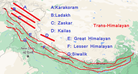
- Also called the Tibetan Himalayas , it consists mainly of Karakorum, Ladakh and Kailash ranges.
- The range acts as a water divide between rivers draining into Bay of Bengal and also the Tibetan lakes.
- Karakoram range determines India’s frontiers with Afghanistan and China. It has many peaks e.g. K-2. Karakoram is also noted for its large glaciers such as Siachean (72 km), Biafo, Baltoro and Hispar.
- The Ladakh Plateau lies to the north-east Karakoram range and highest plateau of the Indian Union. It has been dissected into a number of plains, Aksai-Chin, Depsang plains etc.
The Eastern Hills Or Purvanchal
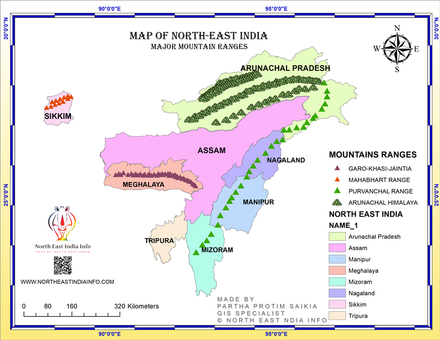
- After crossing the Dihang gorge, the Himalaya takes a sudden southward turn and forms a series of comparatively low hills called Purvanchal.
- In the north is Patkai Bum which forms the international boundary between Arunachal Pradesh and Myanmar. It merges into Naga hills southwards where Saramati is the highest peak.
- To its west is Kohima hills whose highest peak is Japvo.
- South of Naga hills are Manipur hills forming the boundary between Manipur & Myanmar.
- The Barail range separates Naga hills from Manipur hills south of Manipur hills are Mizo hills whose highest point is blue mountain.
- Dapha-Bum is the highest peak of Mishmi hills. Mizo hills are the southernmost part of the north.
Regional Division Of Himalayas
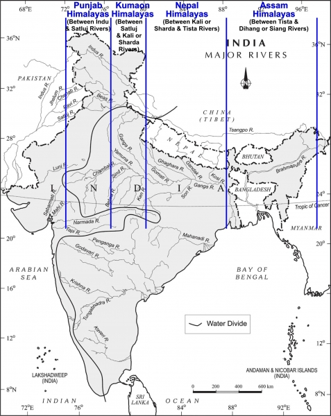
Punjab Himalayas
This 560 km long stretch of the Himalayas lies between the Indus and Sutlej rivers. Karakoram, Ladakh, Piri- Panjal, Zaskar and Dhauldhar are the main ranges of this section while Zojila is the major pass.
The Kumaun Himalayas
It lies between the Satluj and Kali rivers . General elevation is higher than the Punjab Himalayas . Nanda devi , Kamet , Badrinath, Kedarnath, Gangotri are all important peaks of this section. Nainital and Bhimtal are important lake regions of this section.
Nepal Himalayas
This section of Himalayas is situated between the Kali and Tista rivers. Mount Everest, Kanchenjunga, Makalu, Dhaulagiri etc., are located in this section.
The Great Plains – Physical Geography Of India
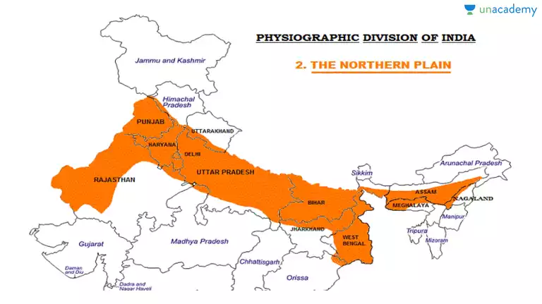
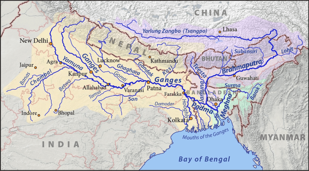
- This is the transition zone between northern mountains and peninsular uplands in the south. It has a profound importance in Physical Geography of India. It is a gradational plain ( depositional plains ) formed by the depositional work of 3 major river systems viz., the Indus, the Ganga and the Brahmaputra plain. Hence also known as the Indo-Gangetic Brahmaputra plain.
- This is the largest alluvial tract of the world extending for a length of 3200 km from mouth of Indus to mouth of Ganga of which Indian sector comprises 400 km. It width decreases eastward. It covers a total area of 7.8 lakh km2. This plain is characterized by an extremely low gradient.
Origin : It is almost universally accepted that this vast expanse of Physical Geography of India has been formed as a result of filling up of a large depression lying between the peninsular and Himalayan region by the deposits of the river coming from these two land for deep warped down between advancing peninsular block and rising Himalayas.
Geomorphology Of The Plains
- The Bhabar is a narrow belt running in east-west direction along the foot of Shivalik. Rivers descending from Himalayas deposit their load along foothills in the form of alluvial fans consisting of gravel, and pebbles. The porosity of the pebble studded rocks is so high that most of the streams sink and flow underground.
- The Tarai is a wide marshy tract in the south of Bhabar running parallel to it. It is characterized by a number of underground streams of the Bhabar belt. It is a zone of excessive dampness, thick forest, rich wildlife and malarial climate.
- Bangar plain is made up of old alluvial soil of the rivers and lies above the flood limit of the plains. The alluvial is of dark color and often impregnated with calcareous concretions known as kankar.
- Khaddar plains is the younger alluvium of flood plains called the khaddar or Bet in Punjab . A new layer of alluvium is deposited by river flood almost every year, confined to the vicinity of the present channels.
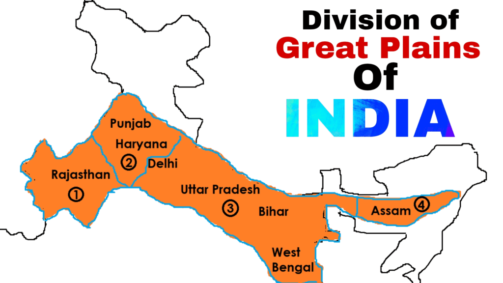
Regional Division Of The Great Plains – Physical Geography Of India
The Rajasthan Plains
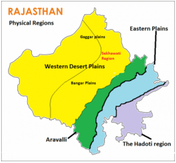
- This includes Marusthali and Rajasthan Bagar areas.
- The great Indian desert of Thar covers the western extremity of the great plains in western Rajasthan. About two-thirds of Indian desert lies in Rajasthan, west of Aravali range and the remaining one-third in neighboring states of Haryana, Punjab and Gujarat.
- The desert proper is called Marusthali and account for a greater part of Marwar plains. In general the eastern part of the Marusthali is rocky while its western part is covered by shifting sand dunes locally known as Dharian.
- The eastern part of Thar desert up to the Aravali range is a semi-arid plain called Rajasthan Bagar.
- The patches of fertile tracks in Bagar are called ‘rohi’. The Luni salt river is the only living river in the arid plain which originates from Annasagar and is lost in the Rann of Kachchh. The tract north of Luni is known as Thali or Sandy plain .
- A part of the plain has also been formed by the recession of the sea as is evidenced by the occurrence of several salt water lakes e.g. Sambhar, Degana, Kuchamau, Pachpadra, Didwara. The Rajasthan plain has several dry beds of rivers ( Saraswati and Drishadvati).
Punjab or Haryana Belt
To the east and north-east of the Thar desert is the Punjab-Haryana plain. Its eastern boundary is formed by the Yamuna River. It is characterized by flat , narrow strips of low lying flood plains known as beds , formed by shifting of river courses . This plain formed by deposits of five rivers is called doab. From east to west these doabs are :
- Bist : between Beas and Satluj
- Bari : between Beas and Ravi
- Rachna : between Ravi and Chenab
- Chaj : between Chenab and Jhelum
- Sindhsagar : between Indus and Jhelum-Chenab.
Rivers in this plain have caused for themselves broad floodplains of Khadar flanked by bleefs, locally called Dhaya. The northern part of this plain adjoining the Shivalik has been eroded by numerous streams called Chhos.
The Ganga Plain
This is the largest-unit of the great plains stretching from Delhi to Kolkata in the straits of Uttar Pradesh , Bihar and West Bengal. Physiographically this plain can be subdivided into following three divisions :
Upper Ganga Plain – Physical Geography Of India
This part is bordered by the Yamuna in the west and the 100 m contour line ( Allahabad-Faizabad railway line) in the east. The upper Ganga plain can be divided into three micro units:
- Ganga-Yamuna-Doab : Between the river ganga and Yamuna forming the largest Doab , it comprises three sections. Upper Doab-from Haridwar to Aligarh, Middle Doab-Aligarh to Kanpur, Lower Doab-Kanpur to Allahabad.
2. Rohilkhand Plain : East of Ganga-Yamuna Doab. It lies entirely in UP and is drained by Rāmgangā, Gomti and Sarda rivers.
3. Awadh Plains: Eastward of Rohilkhand plain drained by Ghagra river.
Middle Ganga Plain
- It occupies eastern UP and Bihar plains. Its eastern boundary corresponds to the Bihar-Bengal border. This is a very low plain, no part of which exceeds 150 m in elevation and alluvial deposits have less concur formations. Besides Ganga, Gomti, Ghagra, Rapti, Gandak, Kosi (in the north) and Son (in the south) are other important rivers.
- It has two parts : north Bihar plain and south Bihar plain (west of Rajasthan hills). Wide plains along Chhapra are known as Chhaurs. On its outward side occur vast lowlands called Jala Patna and Tal near Mokama.
Lower Ganga Plain
It extends from the eastern margin of the Chhota Nagpur plateau in the west to the border of Bangladesh and Assam in the east . Most of these plain is perceived as Deltaic. This plain can be sub-divided into :
North Bengal Plain
- Its eastern part is drained by rivers joining Brahmaputra (Tista, Sankosh) and western part by the tributaries of Ganga (Mahananda, Ajay, Damodar) etc. Further south ward lies the older delta of the Ganga which has been eroded into terraces known as Barind plain.
- Bengal Basin ( Delta Proper ) : The heavily forested Sundarbans in south and the east Bhagirati plain in the north offer contrasting features.
- Rarh Plain : Low land to the west of Bhagirathi. It comprises Birbhum , Asansol rarh , Bankurah and Midnapur Rarh . The rarh plain presents evidence of changing sea levels.
Brahmaputra Plain
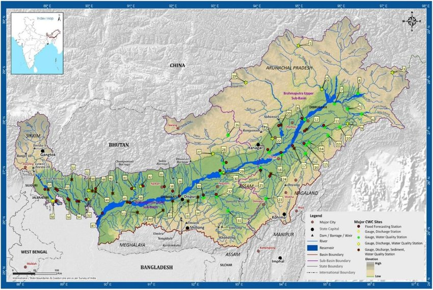
- Also known as Assam valley this is the easternmost part of the great planes.
- These plains extend from Sadiya in the east to Dhibri near Bangladesh border in the west . The region is surrounded by high mountains from all sides except on the west.
- Due to low gradient the Brahmaputra is a highly braided river and has many riverine islands.
- Majuli is the largest river island in the world.
- The right bank tributaries of Brahmaputra form trellis pattern while left bank tributaries form dendritic pattern.
Plateaus of India – Physical Geography Of India
The peninsular plateau is roughly triangular in shapes with base coinciding with the southern edge of the great plains; it covers a total area of 160,0000 km2 ( About half of total land area of the country). The plateaus add another beauty to Physical Geography of India.
Plateaus of India – Locations
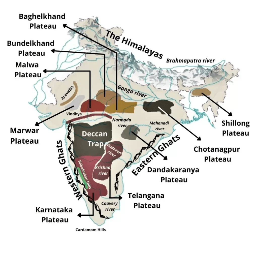
The Marwar Upland – Physical Geography of India
It lies east of Aravali range made up of sandstone, shales and limestone of Vindhyan period. The upland is drained by Banas river originating in Aravali range.
The central Highland – Physical Geography of India
Also called the Madhya Bharat Pathar, lying in the east of Marwar upland and drained by Chambal and its tributaries.
The Bundelkhand upland – Physical Geography of India
To south of Yamuna River between Madhya Bharat Pathar and the Vindhyan scarplands consists of granites and gneiss.
Malwa Plateau – Physical Geography of India
Bonded by Aravali range in the west and Bundelkhand in east and Vindhayas in south. It is an extensive lava plateau in M.P. with black soil drained by a number of north flowing rivers like Betwa, Parbati, Kali Sindh , Chambal and Mahi.
Baghelkhand – Physical Geography of India
East of Makal range and bounded by Son river on the north.
Chhotanagpur plateau – Physical Geography of India
- It covers mostly Jharkhand , joining eastern Madhya Pradesh and Purulia of west Bengal.
- This plateau is composed mainly of Gondwana rocks with patches of granites and gneisses and Deccan lavas.
- The highest general elevation is in the Midwest portion known as Patlands ( high level laterite plateau e.g. Netarhat). The plateau is drained by numerous rivers in a radial pattern such as Damodar Subarnrekha , North koel, south koel and Barakar river.
Meghalaya Plateau – Physical Geography of India
- This plateau has been separated from the main block of the peninsular plateau by a gap called Ganu-Rai mahal gap. From east to west the plateau comprises Garo, Khasi and Jaintia hills and milk hills . Shillong is the highest point of the plateau.
The Deccan plateau – Physical Geography of India
- This is the largest unit covering an area of 5 lakh sq. km It comprises Maharashtra plateau, Karnataka plateau and the Telangana plateau ( Andhra Pradesh). The general slope is from west to east.
- Indicated by flow of major rivers like mahananda, Godawari, Krishna ,and Cauvery.
The Chhattisgarh plain – Physical Geography of India
It is the only plain worth that name in the vast stretch of plateau drained by upper course of Mahanadi . This saucer shaped depression lies between Makal range and Orissa hills.
Other Mountains of India – Physical Geography of India
Aravali range – Physical Geography of India
Aravali is the world’s oldest fold mountain running in north east to southern direction from Delhi to Palampur in Gujarat. This mountain is another unique feature of Physical Geography of India. Gurushikhar is the highest peak situated in mount Abu. Pipli Ghat, Dewair and Desuri passes allow movement by roads and railways.
Vindhyan Range
It rises as an escarpment flaunting the northern edge of the Narmada , Son-trough. The Vindhyan are continued eastward as the Bharner and Kaimur hills. This range acts as a water divide between the Ganga system and river system of south India. The Maikal range forms a connecting link between Vindhya and Satpuras.
Satpura range – Physical Geography of India
It is a series of seven (Sat) mountains running in east-west-direction south of Vindhyas and in between the Narmada and Tapi. Commencing from Rajpipla hills in the west through the Mahadeo hills it extends to Makal range in the east. Dhupgarh near Panchmarhi on Mahadeo hills is the highest peak of Satpuras.
Western Ghats ( Sahyadris )
- The western Ghats run in a north-south direction from Tapil valley to north of Kanyakumari.
- They stretch along the Arabian sea-coast for about 1600 km.
- These are block mountains due to the down warping of the land to the Arabian Sea.
- Sahyadris form the real water divide of the peninsula. All the important up to 160 north latitude are mainly composed of basalt. In this portion Kalsubai is the highest peak. South of Goa Sahyadris are composed of granites and Gneisses .
- In the Nilgiri hills , eastern Ghats join the Sahyadris to form a mountain knot whose highest point is Doddabelta ( 2637 m).
- South of it is the Palghat gap connecting Tamil Nadu Kerala . South of Palghat there is a mountain knot comprising Annamalai hills in the north. Patni hills in the north-east and Cardamom hills in the south.
- Anamudi ( 2696m) situated in the Anamalai hills is the highest peak of the south. Kodaikanal hill station is located on the Patni hills .There are 3 important passes in the Sahyadris.
a. Thalghat b. Bhorghat c. Palghat
Eastern Ghats – Physical Geography of India
- It is a chain of highly broken and has detached hills starting from Mahanadi in Orissa to Vaigai in Tamil Nadu.
- These are part of the very old fold mountains.
- It is only in the northern part between Mahanadi and Godavari that eastern Ghats exhibit true mountain character comprising Malviya and Madugula Konda ranges. South of Godavari the broken hill ranges are Nallamala, Palkonda, Javai, Shavroy and Bilgiri Rangan hills.
- Mahendragiri is the tallest peak of eastern Ghats.
- Both eastern and western ghats add some uniqueness to Physical Geography of India, especially their role in the monsoon rains.
Coastal Plains – Physical Geography of India
- West Coastal Plains: It is 1500 km long from Surat to Cape Comorin . This plain is sub divided into :
- Kachh Plains: Previously an island surrounded by seas and lagoons . In the north of Kachh, lies the great Rann, a broad level salt soaked plain to its south is little Rann.
- Kathiawar Plains: Lying south of Kachh its central part is the highland of Mandu hills having radial drainage . Mount Girnar is the highest point . Further south lies the Gir range.
- Gujarat Plains: East of Kutch and Kathiawar formed by the rivers Narmada, Tapi, Mahi and Sabarmati . It includes the southern part of Gujarat and Gulf of Khambhat coastal Areas.
- Konkan Coast: Extends from Davao to Goa for a distance of about 500 km. Mumbai was an island where the coast is wide east.
More
- Karnataka or Kanara Coast: It extends from Goa to Banglore in a narrow belt. Sharavati river drains this part making Gerosoppa falls.
- Malabar Coast / Kerala Coast: It extends between Bangalore and Kanyakumari. The backwaters locally called Kelyals are the Shallow lagoons . The largest among these is Vembanad lake followed by Ashtamudi. Sand dunes locally called Teris are very common. This coast shows evidence of emergence.
- East Coastal Plain: The east coastal plain is much wider and river than the west and has a number of deltas. The Utkal plain along Orissa coast includes the Mahanadi delta whose most prominent feature is the Chilka lake south of Mahanadi delta. The Andhra plain lying south of Utkal extends up to Pulicat lake. This lake has been barred by a long sand spit known as Sriharikota island . The Andhra plain comprises delta of Godavari and Krishna rivers. Kouru lake is situated between the two deltas . The Tamil Nadu plain extends from Pulikat lake to Kanyakumari comprising the Cauvery delta known as granary of south India.
Physical Geography of India – Islands of India
India has a total of 247 islands ( distant islands) of which 204 lie in Bay of Bengal and Remaining in the Arabian Sea. The presence of so many islands completes the final dressing of Physical Geography of India.
Arabian Sea Islands
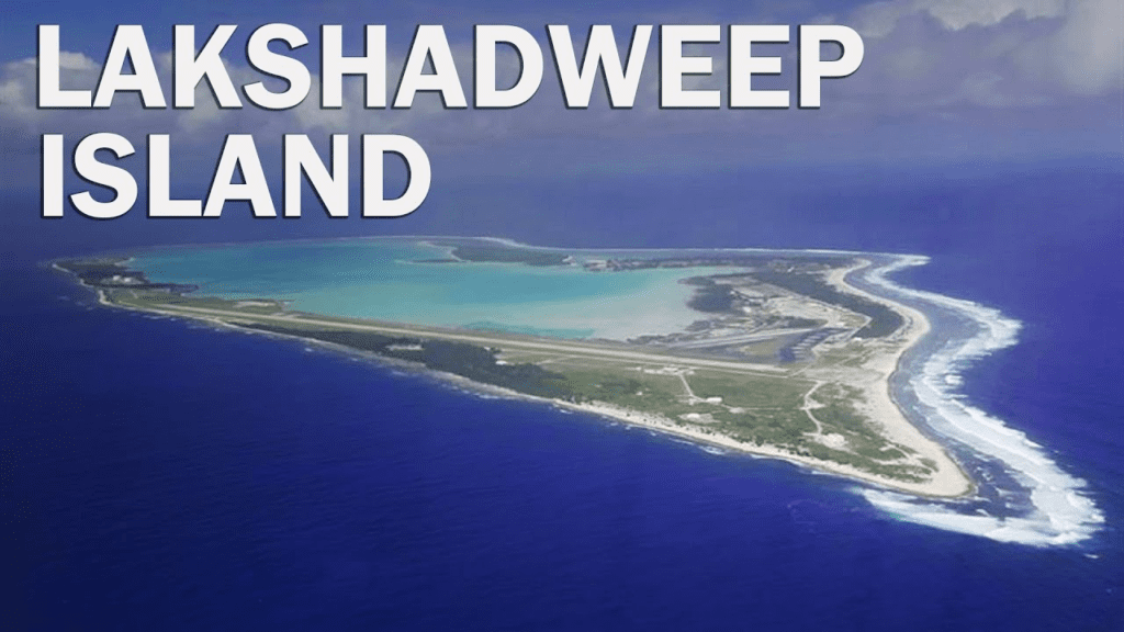
There are 36 islands of Lakshadweep group of island. Kavaratti is the capital of Lakshadweep. The southern most island Minicoy is separated from Maldives by 8 Degree Channel. These islands are of coral origin.
Bay of Bengal Islands – Physical Geography of India
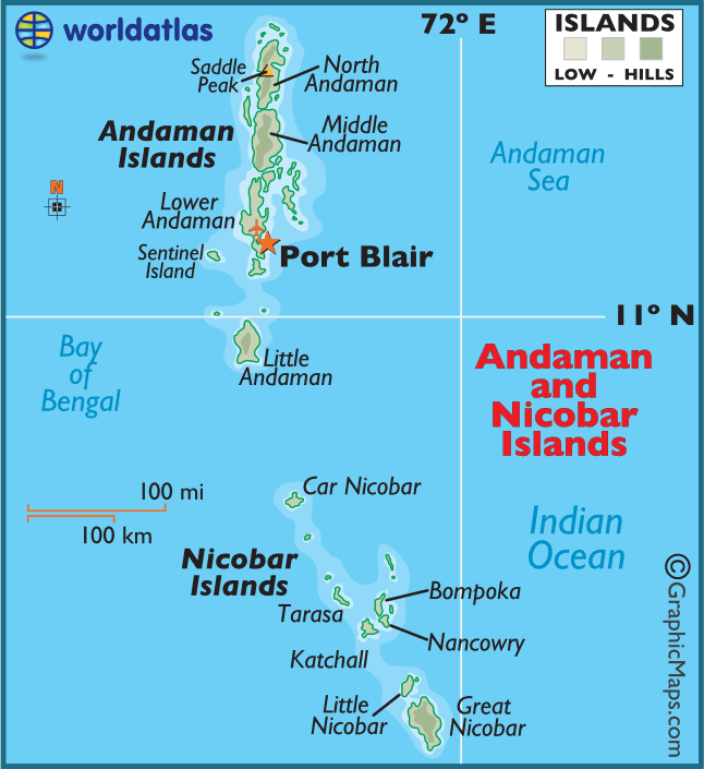
- The Andaman & Nicobar group of islands are separated by 10 Degree Channel. These islands have been formed by extension of the tertiary mountain chain of Arakanyoma . The Andaman group of islands is divided into 3 major groups viz., North Andaman , Middle Andaman and south Andaman, Collectively called Great Andaman.
- Little Andaman is separated from Great Andamans by Duncan passage.
- The Nicobar group of islands consist of 18 islands of which Great Nicobar is largest and southernmost one Saddle peak situated in Andaman is the highest peak of Andaman & Nicobar group.
- The Dhuliar peak is the highest peak of the Nicobar group of islands.
- There are two volcanic islands. The Barren island and Narcondam island.
- They extend to the southernmost point of India that is Indira point ( pygmalion point), another salient aspect of Physical Geography of India.
Offshore Islands – Physical Geography of India
- There are many nearby islands such as Diu , Bhaisala along Kathiawar. Khadiabet and Aliabet along Narmada-Tapi mouth.
- Elephanta, Salsette etc. near Mumbai. Bhatkal ( Mangalore Coast) Anjidiv ( Goa Coast ) Pambam , Crocodile in the gulf of mannar. SriHarikota ( mouth of pulikat ) Parikud, ( mouth of Chilika), Wheeler ( Mahanadi-Brahmani mouth) and New moore and Sagar Ganga Delta.
Conclusion On Physical Geography of India
In conclusion, the physical geography of India is a complex and diverse tapestry that has shaped the country’s history, culture, and environment. With its towering Himalayan peaks in the north, vast alluvial plains in the center, and a rugged peninsular plateau in the south, India’s geography has offered a remarkable blend of natural beauty and challenges. The country’s diverse climate zones, from the arid deserts of Rajasthan to the tropical rainforests of the Western Ghats, have fostered a rich and varied ecosystem, hosting a wide range of flora and fauna.
The perennial rivers that crisscross the Indian subcontinent have been the lifeblood of the nation, supporting agriculture and providing water for millions. However, they also bring challenges like flooding and water scarcity. Understanding and managing these natural resources is essential for sustainable development and the well-being of India’s burgeoning population.
India’s physical geography has played a pivotal role in the nation’s history, from influencing trade routes to shaping the development of unique cultures and traditions across its various regions. As we move forward into an era of increasing environmental awareness and challenges, it is imperative that India continues to study, protect, and manage its natural landscapes and resources for the benefit of current and future generations.
In the face of climate change and the need for sustainable development, a deeper understanding of the physical geography of India is not just a matter of academic interest but a fundamental necessity for policymakers, scientists, and society as a whole. By appreciating and respecting the incredible diversity and beauty of India’s landscapes, and by working together to preserve and manage them wisely, we can ensure a harmonious coexistence with nature while advancing the nation’s progress and prosperity.
See Also
Facts About Universe – In A Nutshell
Picture Of Solar System – At A Glance
FAQs On Physical Geography of India
1. Large Mountains
2. Forests
3. Plateaus
4. Gangetic Plains
5. Thar Desert
All types of topographies are found in India like – Mountains, Plains, Plateaus, Desert, Rivers and lakes and Islands.